Boss skin
| Boss skin | ||
|---|---|---|

|
|
|
| region | Grand Est | |
| Department | Vosges | |
| Arrondissement | Epinal | |
| Canton | Mirecourt | |
| Community association | Mirecourt Dompaire | |
| Coordinates | 48 ° 21 ' N , 6 ° 1' E | |
| height | 342-396 m | |
| surface | 3.18 km 2 | |
| Residents | 46 (January 1, 2017) | |
| Population density | 14 inhabitants / km 2 | |
| Post Code | 88500 | |
| INSEE code | 88100 | |
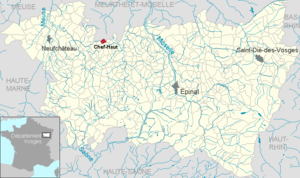
 Location of the municipality of Chef-Haut in the Vosges department |
||
Chef-Haut is a French commune in the Vosges department of the Grand Est region (until 2015 Lorraine ). It belongs to the Arrondissement Épinal and the municipal association Mirecourt Dompaire, founded in 2017 .
geography
The municipality of Chef-Haut, with 46 inhabitants (January 1, 2017), is located in the Xaintois , about 45 kilometers northwest of Épinal and 40 kilometers south of Nancy , on the border with the Meurthe-et-Moselle department .
The eastern municipal boundary runs along the watershed of the basins of the Rhine and Maas . The Rupt des Joncs rises in Chef-Haut and drains westwards to the Maas tributary Vair . Apart from the settlement area and a small, seven hectare forest in the north, the municipal area consists of arable land and grassland.
The neighboring communities of Chef-Haut are Courcelles in the northeast, Blémerey in the east, Oëlleville in the south, Repel in the southwest and Aboncourt in the west and north.
history
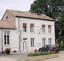
The development of Chef-Haut (before 1766 Chevaul, Chevaux ) is closely linked to the history of today's neighboring municipality of Oëlleville. For the year 1594 the division of the income from the village between the provosts of Châtenois and Neufchâteau on the one hand and the Bailiwick of the County of Vaudémont on the other hand is recorded. In 1841 Chef-Haut came to the Mirecourt Bailiwick . The mayor's and school building (today Mairie ) dates from 1883.
Population development
| year | 1962 | 1968 | 1975 | 1982 | 1990 | 1999 | 2007 | 2017 | |
| Residents | 54 | 63 | 57 | 53 | 54 | 52 | 48 | 46 | |
| Sources: Cassini and INSEE | |||||||||
Attractions
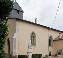
The current church of Saint-Jean-Baptist ( John the Baptist ) emerged from a chapel that was donated by Jean Chrestenoy et Barbe and his wife around 1500 . In 1853 the chapel was rebuilt and enlarged. Some features of the old chapel are still visible, such as the windows of the choir and the bases of the walls and columns.
Economy and Infrastructure
There are five farms in the municipality (breeding horses, cattle, sheep and goats).
Boss skin lies apart from the supraregional traffic flows. Five kilometers south of the village runs the partly two-lane trunk road D 166, which leads from Épinal via Mirecourt to Neufchâteau .
supporting documents
- ↑ Chief skin on vosges-archives.com ( Memento of the original from March 4, 2016 in the Internet Archive ) Info: The archive link was inserted automatically and has not yet been checked. Please check the original and archive link according to the instructions and then remove this notice. (PDF file, French; 109 kB)
- ↑ Chef-Haut on cassini.ehess.fr
- ↑ Chef-Haut on insee.fr
- ^ Genealogy of the Chrestenoy family (French)
- ↑ Farms on annuaire-mairie.fr (French)


