
Bouxières-aux-Bois
| Bouxières-aux-Bois | ||
|---|---|---|
|
||
| region | Grand Est | |
| Department | Vosges | |
| Arrondissement | Epinal | |
| Canton | Charms | |
| Community association | Mirecourt Dompaire | |
| Coordinates | 48 ° 16 ' N , 6 ° 19' E | |
| height | 339-443 m | |
| surface | 7.68 km 2 | |
| Residents | 139 (January 1, 2017) | |
| Population density | 18 inhabitants / km 2 | |
| Post Code | 88270 | |
| INSEE code | 88069 | |
 Mairie Bouxières-aux-Bois |
||

Bouxières-aux-Bois is a French commune with 139 inhabitants (January 1, 2017) in the Vosges department of the Grand Est region ( Lorraine until 2015 ). It belongs to the Arrondissement Épinal and the municipal association Mirecourt Dompaire, founded in 2017 .
geography

The municipality of Bouxières-aux-Bois is 14 kilometers northwest of Épinal in the hill country between the Moselle and Madon .
The terrain in the municipality rises gradually from east to west and reaches a height of 443 meters above sea level in the southwestern tip near the Croix de Virine . About 40% of the community area is made up of forest areas.
Neighboring communities of Bouxières-aux-Bois are Regney and Saint-Vallier in the north, Frizon in the northeast, Mazeley in the southeast, Bocquegney in the south, Circourt in the southwest and Derbamont in the west.
history
The place name appears for the first time in the 11th century. In the Ancien Régime , the Bann Bouxières belonged to the Bailiwick of Darney together with the present-day communities of Madegney and Regney ,
The parish in Bouxières was part of the church in neighboring Derbamont and was under the Remiremont chapter . The current church building was built in 1802, the mayor's house ( Mairie ) was built in 1821.
Population development
| year | 1962 | 1968 | 1975 | 1982 | 1990 | 1999 | 2007 | 2017 | |
|---|---|---|---|---|---|---|---|---|---|
| Residents | 110 | 115 | 94 | 94 | 100 | 123 | 120 | 139 | |
| Sources: Cassini and INSEE | |||||||||
Attractions
- Matthew Church ( Église Saint-Mathieu )
- three lavoirs , one of which is covered

South side of the church
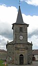
West side of the church


Economy and Infrastructure
There are six farms in the community (vegetable growing, dairy farming, cattle breeding).
The D 32 trunk road from Charmes to Rambervillers runs through the municipality of Essegney . In the nearby town of Charmes there is a connection to the motorway-like RN 57 from Nancy to Épinal . Charmes station, one and a half kilometers from Essegney, is on the Blainville-Damelevières-Lure railway line .
supporting documents
- ↑ Bouxières-aux-Bois on vosges-archives.com. (PDF; 52 kB) (No longer available online.) Archived from the original on March 3, 2016 ; Retrieved July 13, 2011 (French).
- ↑ Bouxières-aux-Bois on cassini.ehess.fr
- ↑ Bouxières-aux-Bois on insee.fr
- ↑ Farms on annuaire-mairie.fr (French)