
Autrey (Vosges)
| Autrey | ||
|---|---|---|
|
||
| region | Grand Est | |
| Department | Vosges | |
| Arrondissement | Epinal | |
| Canton | Saint-Dié-des-Vosges-1 | |
| Community association | Region of Rambervillers | |
| Coordinates | 48 ° 18 ' N , 6 ° 41' E | |
| height | 306-535 m | |
| surface | 17.42 km 2 | |
| Residents | 286 (January 1, 2017) | |
| Population density | 16 inhabitants / km 2 | |
| Post Code | 88700 | |
| INSEE code | 88021 | |
 Mairie from Autrey |
||

Autrey is a French commune in the department of Vosges of the region Grand Est . It belongs to the Arrondissement Épinal and the Région de Rambervillers municipal association founded in 2006 .
geography
The small municipality of Autrey is located in the Mortagne Valley , on the edge of the Vosges . The small town of Rambervillers is seven kilometers north-west, the town of Saint-Dié 20 kilometers east of Autrey. The Abbey of Autrey, visible from afar, was built like many other monasteries in the Middle Ages on what was then the edge of the "wilderness". At this point, the Mortagne River emerges from the narrow mountain valley into a flatter area that can be used for agriculture. The district of Villaume Fobtaine belongs to Autrey . Neighboring municipalities to Autrey are Jeanménil in the north, Housseras in the northeast, La Bourgonce in the east, Mortagne in the south, Fremifontaine in the southwest, Sainte-Hélène in the west and Saint-Gorgon in the northwest.
history

The history of Autrey is inextricably linked with the history of the abbey ( Abbaye Notre-Dame d'Autrey ). The abbey was founded in the middle of the 12th century by the Metz bishop Stephan von Bar . The last abbot of the monastery, Barthélémy-Louis-Martin de Chaumont de la Galaizière, was the first bishop of Saint-Dié in 1777 . The monastery was sold during the French Revolution. Among other things, it served as a wire drawing shop, in 1905 as a hospice and from 1931 to 1975 seminars took place here.
Population development
With 286 inhabitants (as of January 1, 2017) Autrey is one of the small communities in the Vosges department.
| year | 1962 | 1968 | 1975 | 1982 | 1990 | 1999 | 2008 | 2017 | |
|---|---|---|---|---|---|---|---|---|---|
| Residents | 218 | 223 | 195 | 204 | 287 | 297 | 303 | 286 | |
| Sources: Cassini and INSEE | |||||||||
Attractions
- former Notre-Dame monastery from the 12th century with cloister and monastery church, reconstructed in the mid-16th century (the Jacquot organ dates from 1954); classified as a monument historique since 1955
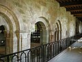
Romanesque arches of the cloister
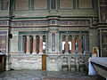
colonnade

Church window
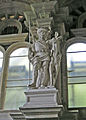
St. Hubert statue

.jpg)
.jpg)
.jpg)
- Botanical garden ( Jardin botanique de Gondremer ) with over 4000 plants. The privately operated garden has to Kalmia , heather plants , of subjects and Japanese maple specialized. There are also rare conifers, hydrangeas , magnolias , prunus , daylilies and hostas . The design of the botanical garden goes back to Brother Simeon , who belonged to the Catholic community of the Beatitudes , which has been managing the monastery since 1982.

Entrance to the botanical garden

Garden cutout
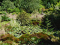
Water lily plant
.jpg)
.jpg)
Economy and Infrastructure
Until well into the 20th century, Autrey was a predominantly agricultural village. Nine farms are located in the community (cereal and vegetable growing, dairy farming, horse breeding). Today the residents live mainly from activities in the tourist sector (gastronomy, hotel business) around the former monastery, which is highly frequented by visitors, and the botanical garden. Outside of this sector there are few jobs in the village. Some workers are commuters who work in the surrounding larger towns.
The village is located away from the major thoroughfares on a departmental road that leads from Rambervillers to Brouvelieures . The next connection to the motorway-like RN 57 is about 18 kilometers away. There are other road connections to Sainte-Hélène, Housseras and Mortagne.
supporting documents
- ↑ Notre-Dame Abbey on vosges-archives.com ( Memento of March 3, 2016 in the Internet Archive ) (PDF file, French)
- ↑ Autrey on cassini.ehess.fr
- ↑ Autrey on insee.fr
- ^ Entry in the Base Mérimée of the Ministry of Culture
- ↑ Farms on annuaire-mairie.fr (French)