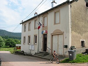
Belmont-sur-Buttant
| Belmont-sur-Buttant | ||
|---|---|---|

|
|
|
| region | Grand Est | |
| Department | Vosges | |
| Arrondissement | Epinal | |
| Canton | Bruyères | |
| Community association | Bruyères-Vallons des Vosges | |
| Coordinates | 48 ° 11 ' N , 6 ° 47' E | |
| height | 383-668 m | |
| surface | 8.46 km 2 | |
| Residents | 302 (January 1, 2017) | |
| Population density | 36 inhabitants / km 2 | |
| Post Code | 88600 | |
| INSEE code | 88050 | |
 Mairie Belmont-sur-Buttant |
||
Belmont-sur-Buttant is a French commune with 302 inhabitants (as of January 1, 2017) in the Vosges department in the Grand Est region (until 2015 Lorraine ). It belongs to the Arrondissement of Épinal and the canton of Bruyères .
geography
Surrounded by forests, the municipality in the western foothills of the Vosges is about 20 kilometers southwest of Saint-Dié-des-Vosges and about 25 kilometers northeast of Épinal . The eponymous Ruisseau de Buttant flows through the municipality , a narrow stream that drains via the Mortagne and Meurthe to the Moselle . The village is surrounded in a semicircle by extensive forests ( Forêt communale de Belmont, Forêt communale de Domfaing, Forêt communale de Brouvelieures ), which stretch along the mountain ridges. The highest point is the Tête de la Clochette (668 m) in the southeast of the municipality. In the west rises the striking, 444 m high Haut de Belmont , which - located exactly in the middle between the municipalities of Belmont, Domfaing and Vervezelle - was chosen as the location for the church of Saint-Laurent.
The settlement structure of the municipality of Belmont-sur-Buttant is very loose, there is no pronounced village center, only around the town hall ( Mairie ) the development is a bit denser. In addition to the district of Machitour, the municipality includes numerous small named and unnamed hamlets and individual farms.
Neighboring municipalities of Belmont-sur-Buttant are Bois-de-Champ in the northeast, Biffontaine and Les Poulières in the southeast, La Chapelle-devant-Bruyères in the south, Bruyères in the southwest, Vervezelle in the west and Domfaing in the northwest.
history
In 1867, Belmont was given the suffix sur-Buttant and has had its current name ever since.
In 1867 Belmont-sur-Buttant consisted of the following hamlets and resettlements:
|
|
Of the total area of 846 hectares, 190 hectares were usable, 135 hectares of meadow, 403 hectares of forest, 111 hectares (fruit) gardens and 6 hectares of wasteland.
At that time there was a mill, a factory for the extraction of starch and four craft shops.
Population development
| year | 1962 | 1968 | 1975 | 1982 | 1990 | 1999 | 2007 |
| Residents | 219 | 235 | 220 | 246 | 255 | 256 | 275 |
In 1710, Belmont had just 109 inhabitants. During the 12th year of the revolutionary calendar (1803/1804) the population was already 475. In 1830 there were 498, in 1847 already 552. In 1867 Belmont had 492 inhabitants.
Attractions
- Parish Church of St. Laurentius ( Saint-Laurent ) for the three parishes of Belmont, Domfaing and Vervezelle on the Haut de Belmont ; the rust in the coat of arms of the municipality symbolizes the martyrdom of St. Lawrence of Rome


