
Biffontaine
| Biffontaine | ||
|---|---|---|

|
|
|
| region | Grand Est | |
| Department | Vosges | |
| Arrondissement | Saint-Dié-des-Vosges | |
| Canton | Bruyères | |
| Community association | Saint-Dié-des-Vosges | |
| Coordinates | 48 ° 13 ' N , 6 ° 48' E | |
| height | 456-662 m | |
| surface | 8.88 km 2 | |
| Residents | 408 (January 1, 2017) | |
| Population density | 46 inhabitants / km 2 | |
| Post Code | 88430 | |
| INSEE code | 88059 | |
 Town hall and school building in Biffontaine |
||

Biffontaine is a French commune with 408 inhabitants (January 1, 2017) in the Vosges department in the Grand Est region (until 2015 Lorraine ). It belongs to the arrondissement of Saint-Dié-des-Vosges and to the municipal association of Saint-Dié-des-Vosges, founded in 2017 .
geography
The municipality is located on the upper reaches of the Neuné River , a tributary of the Vologne , about 18 kilometers southwest of the city of Saint-Dié-des-Vosges . Neighboring municipalities of Biffontaine are Bois-de-Champ in the north, La Houssière in the east, La Chapelle-devant-Bruyères in the south, Les Poulières in the south-west and Belmont-sur-Buttant in the north-west.
In the municipality of Biffontaine, the river Neuné divides due to the low gradient into several river arms that reunite a few kilometers downstream. The north of the commune is forested ( Forêt Communale de Biffontaine ) and strongly indented. Some elevations reach over 590 m above sea level. These include:
|
The highest point in the municipality at 662 m is an unnamed elevation in the northeast on the border with the municipality of La Houssière.
The districts of L'Épaxe and Les Censes des Arbois belong to the 8.88 km² community of Biffontaine .
history
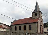
During the Ancien Régime , Biffontaine and its surroundings were under the influence of the parish of Champ-le-Duc as part of the Remiremont chapter , whose canonies levied taxes. The church of St. Antonius ( Église Saint-Antoine ) was built in the second half of the 18th century in place of a dilapidated previous building. It contains an organ from 1853 and an extension was added in 1931. There is also a calvary right next to today's church from the 18th century. In 1876, Biffontaine received a railway connection on the railway line from Épinal to Saint-Dié-des-Vosges . In October 1944, heavy fighting between the advancing American troops and the German Wehrmacht took place between Biffontaine and Bruyères . On the American side, the 442nd Infantry Regiment and the 100th Infantry Battalion operated with many Hawaiian soldiers of Japanese origin.
Population development
| year | 1962 | 1968 | 1975 | 1982 | 1990 | 1999 | 2008 | 2017 | |
| Residents | 395 | 376 | 353 | 308 | 393 | 399 | 445 | 408 | |
| Sources: Cassini and INSEE | |||||||||
Attractions
- Church of St. Anthony in Biffontaine


Economy and Infrastructure
In the municipality of Biffontaine there are still five farms (vegetable and potato cultivation, dairy farming, cattle breeding). In addition, crafts and tourism are playing an increasing role.
The main road in the municipality connects as the D 31 Biffontaine with the small towns of Bruyères and Corcieux . A side road leads north to Les Rouges-Eaux in the upper Mortagnetal valley . 21 kilometers northeast of Biffontaine there is a connection to the motorway-like RN 59 from Saint-Dié-des-Vosges to Lunéville .