Vexaincourt
| Vexaincourt | ||
|---|---|---|

|
|
|
| region | Grand Est | |
| Department | Vosges | |
| Arrondissement | Saint-Dié-des-Vosges | |
| Canton | Raon-l'Étape | |
| Community association | Saint-Dié-des-Vosges | |
| Coordinates | 48 ° 30 ' N , 7 ° 3' E | |
| height | 355-880 m | |
| surface | 11.38 km 2 | |
| Residents | 157 (January 1, 2017) | |
| Population density | 14 inhabitants / km 2 | |
| Post Code | 88110 | |
| INSEE code | 88503 | |
 St. Michael Church |
||
Vexaincourt is a French commune with 157 inhabitants (as of January 1, 2017) in the Vosges department in the Grand Est region (until 2015 Lorraine ). It belongs to the canton of Raon-l'Étape in the arrondissement of Saint-Dié-des-Vosges .
geography
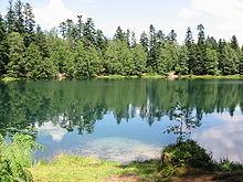
The Vosges community Vexaincourt is located on the Meurthe tributary, the Plaine , which forms the border between the Vosges and Meurthe-et-Moselle departments . The department road 392, which leads from Raon-l'Étape over the Vosges ridge to Schirmeck in Alsace , bypasses the municipality to the north. In the municipality of Vexaincourt is the Lac de la Maix , a small lake surrounded by wooded areas.
history
Until 1793 the settlement belonged to the Principality of Salm .
Web links
Commons : Vexaincourt - collection of images, videos and audio files


