
Pierre-Percée (Meurthe-et-Moselle)
| Pierre-Percée | ||
|---|---|---|

|
|
|
| region | Grand Est | |
| Department | Meurthe-et-Moselle | |
| Arrondissement | Luneville | |
| Canton | Baccarat | |
| Community association | Saint-Dié-des-Vosges | |
| Coordinates | 48 ° 28 ' N , 6 ° 56' E | |
| height | 301-570 m | |
| surface | 9.93 km 2 | |
| Residents | 92 (January 1, 2017) | |
| Population density | 9 inhabitants / km 2 | |
| Post Code | 54540 | |
| INSEE code | 54427 | |
 Townscape |
||

Pierre-Percée ( German Langstein ) is a French commune with 92 inhabitants (as of January 1, 2017) in the Meurthe-et-Moselle department in the Grand Est region (until 2015 Lorraine ). It belongs to the Arrondissement of Lunéville and the Canton of Baccarat .
geography
The municipality is located around 60 kilometers southeast of Nancy on the border with the neighboring Vosges department , on the eastern bank of the Lac de Pierre-Percée reservoir , which was built for the emergency cooling of the Cattenom nuclear power plant 100 kilometers away . The Plaine River runs along the eastern municipal boundary . The neighboring municipalities are Angomont in the north, Bionville in the northeast, Celles-sur-Plaine in the southeast (Département Vosges), Neufmaisons in the south, Pexonne in the west and Badonviller in the northwest.
Population development
| year | 1968 | 1975 | 1982 | 1990 | 1999 | 2006 | 2014 |
| Residents | 76 | 94 | 80 | 80 | 95 | 86 | 94 |
Attractions
- Ruins of the 12th century Pierre-Percée Castle - Monument historique
- War memorial for the fallen soldiers of the First World War - Monument historique
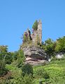
View of the ruins of the castle

Lac de Pierre-Percée with dam
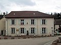
town hall


Web links
Individual evidence
- ↑ E. Grosse: Dictionnaire statistique du Département de la Meurthe - contenant une introduction historique sur le pays avec une notice sur chacune de ses villes, bourgs, villages. Creusat, Lunéville 1836
- ^ Pierre-Percée Castle in the Base Mérimée of the French Ministry of Culture (French)
- ↑ War memorial in the Base Mérimée of the French Ministry of Culture (French)