
Thiaville-sur-Meurthe
| Thiaville-sur-Meurthe | ||
|---|---|---|

|
|
|
| region | Grand Est | |
| Department | Meurthe-et-Moselle | |
| Arrondissement | Luneville | |
| Canton | Baccarat | |
| Community association | Territoire de Lunéville à Baccarat | |
| Coordinates | 48 ° 25 ' N , 6 ° 49' E | |
| height | 273-365 m | |
| surface | 4.47 km 2 | |
| Residents | 573 (January 1, 2017) | |
| Population density | 128 inhabitants / km 2 | |
| Post Code | 54120 | |
| INSEE code | 54519 | |
_mairie_et_salle_Poirel.jpg) Town hall (Mairie) of Thiaville-sur-Meurthe |
||

Thiaville-sur-Meurthe is a French commune with 573 inhabitants (as of January 1, 2017) in the Meurthe-et-Moselle department in the Grand Est region (before 2016 Lorraine ). It belongs to the Arrondissement of Lunéville and the Canton of Baccarat . The inhabitants call themselves Thiavillois (es) .
geography
The municipality is located about 55 kilometers southeast of Nancy in the south of the Meurthe-et-Moselle department on the border with the Vosges department . Neighboring communities are Bertrichamps in the north, Raon-l'Étape (in the Vosges department) in the east, Sainte-Barbe (in the Vosges department) in the south and Lachapelle in the west. The municipality consists of the village of Thiaville-sur-Meurthe, the hamlet of Bellevue that has grown together with it , the hamlet of Fagnoux and some groups of houses and individual farms. The Meurthe river crosses the municipality and in parts forms the municipality boundary. Large parts of the municipality are forested.
history
The present community is mentioned in a document under the name Thiadivilla . Thiaville-sur-Meurthe historically belonged to the province of Trois-Évêchés (Three Bishoprics), which in fact fell to France in 1552. Until the French Revolution , the community was then in the Grand-gouvernement de Lorraine-et-Barrois . From 1793 to 1801 the community was assigned to the Lunéville district. It has been part of the canton of Baccarat since 1793. Since 1801 it has also been assigned to the Arrondissement of Lunéville. Until 1871, the community was in the old Meurthe department . Since then it has been part of the Meurthe-et-Moselle department. Until 1926 the municipality was only called Thiaville.
Population development
| year | 1793 | 1836 | 1911 | 1946 | 1962 | 1968 | 1975 | 1982 | 1990 | 1999 | 2007 | 2015 |
| Residents | 458 | 641 | 552 | 368 | 418 | 421 | 470 | 560 | 577 | 537 | 483 | 562 |
| Source: Cassini and INSEE | ||||||||||||
traffic
Thiaville-sur-Meurthe is on the railway line from Lunéville to Saint-Dié-des-Vosges and has its own train station. The N59 runs through the middle of the municipality with a full connection at the municipal boundary to Raon-l'Étape. The D158, which runs through the village, is important for regional traffic.
Attractions
- 19th century village church of Saint Joseph
- two former mills (in rue de la libération and rue du moulin)
- Memorial to the Fallen
- several wells
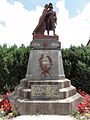
- Memorial to Pierre Pierron

Station / stop of the municipality

one of the wells in the parish
Memorial to the Fallen

Saint-Joseph village church

Memorial to Pierre Pierron
_la_gare_(01).jpg)
_fontaine_C.jpg)
_monument_aux_morts.jpg)
_%C3%A9glise_(02).jpg)
_m%C3%A9morial_Pierre_Pierron_fusill%C3%A9.jpg)
Individual evidence
Web links