
Arracourt
| Arracourt | ||
|---|---|---|

|
|
|
| region | Grand Est | |
| Department | Meurthe-et-Moselle | |
| Arrondissement | Luneville | |
| Canton | Baccarat | |
| Community association | Pays du Sânon | |
| Coordinates | 48 ° 43 ' N , 6 ° 32' E | |
| height | 215-335 m | |
| surface | 17.41 km 2 | |
| Residents | 246 (January 1, 2017) | |
| Population density | 14 inhabitants / km 2 | |
| Post Code | 54370 | |
| INSEE code | 54023 | |
 View to St. Mauritius Church |
||

Arracourt is a French commune with 246 inhabitants (as of January 1, 2017) in the Meurthe-et-Moselle department in the Grand Est region . It belongs to the Arrondissement Lunéville and the municipality association Pays du Sânon .
geography
Arracourt is located at 230 m above sea level, about 18 kilometers north of the city of Lunéville and about 28 kilometers east-northeast of the city of Nancy . In the north, the area of the municipality borders on the Moselle department .
The municipality covers a section of the Loutre Noire valley. The almost 18 km long Loutre Noire rises east of Arracourt and flows into the Moselle tributary Seille at Pettoncourt . The terrain gradually rises north and south of the valley area. In the north, the ridge of the Haut des Monts and the large forest area Forêt Domaniale de Bezange-la-Grande lead over to the Seilletal; in the south, the heights of the Bois de Bénamont form the border with the catchment area of the Sânon . Except for the forests in the north and south, the community area is characterized by large arable land.
Arracourt includes the hamlets of Vaudrécourt and Riouville - the latter consisting of the farms Basse Riouville, Haute Riouville and La Quittaine .
Neighboring municipalities of Arracourt are Vic-sur-Seille in the north, Juvrecourt in the northeast, Réchicourt-la-Petite in the east, Bures in the southeast, Bathelémont in the south, Athienville in the west and Bezange-la-Grande in the northwest.
history
The village of Arracourt was on the border with the German Empire from 1871 to 1914.
The objects in Arracourt that were destroyed at the beginning of the First World War included the 18th century castle, the church and a chapel. The castle was not rebuilt, the Notre-Dame-de-Pitié chapel was reconstructed in 1918, and the St. Mauritius church was rebuilt in 1920. Richard Deeken , founder of the German Samoa Society , writer and colonial politician, was killed in the fighting in Arracourt .
In September 1944 a tank battle took place around Arracourt, in which the 4th Division of the 3rd US Army and the 5th Panzer Army of the Wehrmacht faced each other. It went down in history as the Battle of Arracourt .
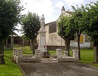
Memorial to the fallen of the two world wars 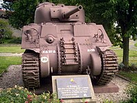
Sherman tank in memory of the Battle of Arracourt in 1944


Population development
| year | 1962 | 1968 | 1975 | 1982 | 1990 | 1999 | 2007 | 2016 |
| Residents | 362 | 321 | 259 | 215 | 259 | 234 | 241 | 247 |
| Sources: Cassini and INSEE | ||||||||
Attractions
- Church of St. Mauritius ( Église Saint-Maurice )
- Notre-Dame-de-Pitié chapel with a carved sculpture of the Virgin Mary
Economy and Infrastructure
Arracourt is a primary school and kindergarten location ( École élémentaire publique ).
There are ten farms in the municipality of Arracourt (cultivation of grain, potatoes and vegetables, cattle breeding).
The trunk road leads through Arracourt from Lunéville via Moyenvic to Château-Salins . Other roads connect the village with the neighboring communities of Juvrecourt, Réchicourt-la-Petite, Athienville and Bezange-la-Grande.
supporting documents
- ↑ Arracourt on cassini.ehess.fr (French)
- ↑ Arracourt on INSEE
- ↑ Farms on annuaire-mairie.fr (French)