Neuviller-lès-Badonviller
| Neuviller-lès-Badonviller | ||
|---|---|---|

|
|
|
| region | Grand Est | |
| Department | Meurthe-et-Moselle | |
| Arrondissement | Luneville | |
| Canton | Baccarat | |
| Community association | Vezouze en Piémont | |
| Coordinates | 48 ° 31 ' N , 6 ° 52' E | |
| height | 289-341 m | |
| surface | 5.75 km 2 | |
| Residents | 94 (January 1, 2017) | |
| Population density | 16 inhabitants / km 2 | |
| Post Code | 54540 | |
| INSEE code | 54398 | |
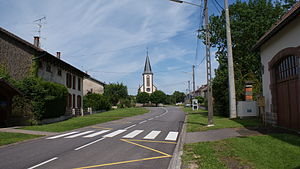
 Village center with a view of L'Invention-de-la-Croix et Saint-Laurent church |
||
Neuviller-lès-Badonviller is a French commune in the Meurthe-et-Moselle department in the Grand Est region (until 2015 Lorraine ).
Earlier spellings were: Nuefveilleir (1329), Novumvillare (1402), Neufeiller (1590).
geography
The community is located at the foot of the Vosges on a side stream of the Blette , 30 kilometers southeast of Lunéville . Neighboring municipalities of Neuviller-lès-Badonviller are Montreux in the north, Bréménil in the northeast, Badonviller in the south and Ancerviller in the west.
Population development
| year | 1946 | 1962 | 1968 | 1975 | 1982 | 1990 | 1999 | 2006 | 2009 |
| Residents | 146 | 107 | 113 | 117 | 96 | 80 | 80 | 89 | 92 |
Attractions
- Church of the Finding of the Cross and St. Lawrence Church ( Église de l'Invention-de-la-Croix et Saint-Laurent )
Web links
Commons : Neuviller-lès-Badonviller - collection of images, videos and audio files
