
Réclonville
| Réclonville | ||
|---|---|---|

|
|
|
| region | Grand Est | |
| Department | Meurthe-et-Moselle | |
| Arrondissement | Luneville | |
| Canton | Baccarat | |
| Community association | Vezouze en Piémont | |
| Coordinates | 48 ° 32 ' N , 6 ° 44' E | |
| height | 247-312 m | |
| surface | 2.96 km 2 | |
| Residents | 76 (January 1, 2017) | |
| Population density | 26 inhabitants / km 2 | |
| Post Code | 54450 | |
| INSEE code | 54447 | |
_mairie.jpg) Town hall (Mairie) of the municipality |
||

Réclonville is a French commune with 76 inhabitants (as of January 1, 2017) in the Meurthe-et-Moselle department in the Grand Est region (before 2016 Lorraine ). It belongs to the Arrondissement of Lunéville and the Canton of Baccarat (until 2015 the Canton of Blâmont ). Its inhabitants call themselves Réclonvillois (es) .
geography
The municipality is located about 43 kilometers southeast of Nancy in the southeast of the Meurthe-et-Moselle department. The village is located on the left bank of the Verdurette , which crosses the municipality and in parts forms the municipal boundary. Neighboring communities are Herbéviller in the north and north-east, Pettonville in the east and south-east, Hablainville in the south-west, Buriville in the west and Ogéviller in the north-west and north.
history
The present parish is first mentioned in a document in 1300 as Reclonvile . Historically, Réclonville belonged to the bailiwick (Bailliage) Lunéville and thus to the Duchy of Lorraine , which fell to France in 1766. Until the French Revolution , the community was then in the Grand-gouvernement de Lorraine-et-Barrois . From 1793 to 1801 the municipality was assigned to the Blâmont district and the canton of Ogeviller. Since 1801 Réclonville has also been assigned to the Arrondissement of Lunéville. From 1801 to 2015, the municipality was within the canton of Blâmont and has been part of the canton of Baccarat ever since. Until 1871, the community was in the old Meurt (h) e. Since then it has been part of the Meurthe-et-Moselle department .
Population development
| year | 1793 | 1861 | 1962 | 1968 | 1975 | 1982 | 1990 | 1999 | 2007 | 2015 |
| Residents | 144 | 231 | 89 | 92 | 84 | 74 | 68 | 77 | 77 | 73 |
| Source: Cassini and INSEE | ||||||||||
traffic
Réclonville is located near the railway line from Lunéville to Saint-Dié-des-Vosges. The nearest stop is in the neighboring municipality of Azerailles. Not far from the municipality, the N59 passes with a partial connection towards Lunéville in Azerailles and a full connection in Gélacourt. The D19, which runs through the village, is important for regional traffic.
Attractions
- Saint-Sylvestre village church from the 18th century
- Memorial to the Fallen
- Crossroads on the Au Petit Bocca road

Saint-Sylvestre village church

Interior of the village church
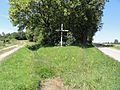
Crossroads on the Au Petit Bocca road

Door portal

The Verdurette in Réclonville
_%C3%A9glise_(01).jpg)
_%C3%A9glise_(02).jpg)
_croix_de_chemin.jpg)
_porte_maison.jpg)
_la_Verdurette.jpg)