Xermaménil
| Xermaménil | ||
|---|---|---|

|
|
|
| region | Grand Est | |
| Department | Meurthe-et-Moselle | |
| Arrondissement | Luneville | |
| Canton | Lunéville-2 | |
| Community association | Territoire de Lunéville à Baccarat | |
| Coordinates | 48 ° 32 ' N , 6 ° 28' E | |
| height | 218-293 m | |
| surface | 10.94 km 2 | |
| Residents | 556 (January 1, 2017) | |
| Population density | 51 inhabitants / km 2 | |
| Post Code | 54300 | |
| INSEE code | 54595 | |
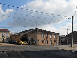
 Mairie Xermaménil |
||
Xermaménil is a French commune with 556 inhabitants (as of January 1, 2017) in the Meurthe-et-Moselle department in the Grand Est region . It belongs to the Arrondissement Lunéville and the municipal association Territoire de Lunéville à Baccarat .
geography
The municipality of Xermaménil is located on the lower Mortagne , shortly before its confluence with the Meurthe , about ten kilometers southeast of Lunéville , in the south of the Meurthe-et-Moselle department.
The almost 11 km² large municipal area is characterized on the one hand by the wide Mortagnetal valley, which is used intensively for agriculture. The second large natural area is a slightly hilly plateau, which extends between the largely parallel rivers Meurthe and Mortagne and has a dense forest cover ( Bois de Saint-Mansuy, Bois du Poteau , parts of an approx. 30 km² contiguous forest area) . Numerous streams arise in the woods, some of which drain to Mortagne ( Ruisseau de Norbéménil, Ruisseau d'Apré in the municipality of Xermaménil). On their way they feed a few small ponds. The flowing waters that arise in the east of the municipality reach the Meurthe via the Laxat . At 293 m above sea level, the Bois du Poteau is the highest altitude in the municipality.
The districts and hamlets of La Tuilerie, Le Magasin and La Louvière belong to Xermaménil .
Neighboring municipalities of Xermaménil are: Rehainviller in the north, Hériménil in the northeast and east, Gerbéviller in the southeast, Lamath in the southwest and Mont-sur-Meurthe in the northwest.
history
The community was first mentioned in a document in the 12th century. The place name developed from Sarmanmasnil (1178) via Xarmamenil (1296), Xarmanmengny (1304) and Xermamesny (1316) to Xermaménil , which is still in use today . On the eve of the French Revolution , Xermaménil and the surrounding lands belonged to Messrs Riste from Nomeny . The coat of arms with the Mühleisen framed by four crosses, which was only adopted by the municipality in 1983 , indicates that Xermaménil was part of the Gerbéviller barony , which was raised to a margraviate in 1737 .
According to a survey from 1907, there were among the then 334 residents of the community:
|
|
Origin of name
The ending -ménil, which is very common in north-eastern France, stands for -mühle . Xerma is derived from germain (Germanic) .
Population development
| year | 1962 | 1968 | 1975 | 1982 | 1990 | 1999 | 2007 | 2017 | |
| Residents | 297 | 283 | 273 | 305 | 410 | 423 | 516 | 566 | |
| Sources: Cassini and INSEE | |||||||||
Attractions
- Church of St. Mansuetus ( Église Saint-Mansuy )
- many renovated houses with the rounded yard and barn doors typical of Lorraine
- The former grist mill as the nucleus of the village was built on an artificial branch of the Mortagne. The buildings still preserved today date from the 18th century. For a long time, in addition to flour, bark and earthenware were also ground here to produce dyes. In 1890 the first turbine was installed in the mill, which was replaced in 1980 by a new, electricity-producing turbine from EDF .
- Froment Castle ( Château de Froment ) from the 19th century
Economy and Infrastructure
There are six farms in the municipality (cereal cultivation, cattle breeding). In addition, the residents live on small craft businesses or work in the stoneware factory in nearby Saint-Clément . Several residents also commute to the nearby administrative center of Lunéville.
The trunk road from Lunéville to Rambervillers (D 414) runs through Xermaménil and follows the Mortagne river valley. From this road branches off in Xermaménil another nationally important road to Haroué (D 9). Another road connects Xermaménil with the municipality of Mont-sur-Meurthe . The Xermaménil-Lamath station , on the left bank of Mortagne in the municipality of Lamath , offered connections to the larger towns in the area from the completion of the Mont-sur-Meurthe - Bruyères railway line in 1911 to its final closure in 1980. From 1990 to 1993 it was possible the partial section of Xermaménil-Lamath after Deinvillers with Handcars to navigate. The bus line 14 Lunéville - Rambervillers - Bruyères, operated by TER Lorraine , stops every hour in Xermaménil, replacing the disused railway line.
supporting documents
- ↑ virtual tour of Xermaménil. (PDF; 1.2 MB) Archived from the original on March 4, 2016 ; Retrieved October 28, 2012 (French).
- ↑ Description of the coat of arms on genealogie-lorraine.fr (French)
- ^ Toponymie de Lorraine (French)
- ↑ Xermaménil on cassini.ehess.fr
- ↑ Xermaménil on insee.fr
- ↑ Farms on annuaire-mairie.fr (French)


