
Laneuveville-aux-Bois
| Laneuveville-aux-Bois | ||
|---|---|---|

|
|
|
| region | Grand Est | |
| Department | Meurthe-et-Moselle | |
| Arrondissement | Luneville | |
| Canton | Baccarat | |
| Community association | Territoire de Lunéville à Baccarat | |
| Coordinates | 48 ° 37 ' N , 6 ° 39' E | |
| height | 232-303 m | |
| surface | 19.04 km 2 | |
| Residents | 319 (January 1, 2017) | |
| Population density | 17 inhabitants / km 2 | |
| Post Code | 54370 | |
| INSEE code | 54297 | |
_mairie.jpg) Town hall (Mairie) of the village |
||

Laneuveville-aux-Bois is a French commune with 319 inhabitants (as of January 1, 2017) in the Meurthe-et-Moselle department in the Grand Est region (before 2016 Lorraine ). It belongs to the Arrondissement of Lunéville and the Canton of Baccarat (until 2015 the Canton of Lunéville-Sud ). The inhabitants call themselves Laneuvillois (es) .
geography
The municipality is located about 35 kilometers southeast of Nancy in the south of the Meurthe-et-Moselle department. The village is located in a valley on the Ruisseau des Amis stream . Neighboring communities are Parroy in the north, Mouacourt in the northeast, Emberménil in the east, Vého in the southeast, Manonviller in the south, Thiébauménil in the southwest, Marainviller and Croismare in the west and Crion and Hénaménil in the northwest. The community consists of the village of Laneuveville-aux-Bois, the hamlet of Saint-Georges and some groups of houses and individual farms. Large parts of the community are forested.
history
Today's community is first mentioned in a document in 922 under the Latin name Novovillare . The community was originally a logging village. Laneuveville-aux-Bois was badly damaged in the Thirty Years War . The community was in the Bailiwick (Bailliage) Lunéville and historically belonged to the Duchy of Lorraine , which fell to France in 1766. Until the French Revolution , the community was then in the Grand-gouvernement de Lorraine-et-Barrois . From 1793 to 1801, the community was assigned to the Lunéville district and incorporated into the canton of La Neuveville aux Bois (for a few months earlier, the canton of Bénaménil). Laneuveville-aux-Bois (then called La Neuveville aux Bois) was the capital of this canton. Since 1801 it was assigned to the canton of Lunéville-Sud-Est (which became the canton of Lunéville-Sud in 1825) and the arrondissement of Lunéville. Until 1871, the community was in the old Meurt (h) e. Since then it has been part of the Meurthe-et-Moselle department .
Population development
| year | 1793 | 1846 | 1911 | 1921 | 1962 | 1968 | 1975 | 1982 | 1990 | 1999 | 2007 | 2015 |
| Residents | 439 | 618 | 435 | 312 | 327 | 320 | 296 | 294 | 318 | 303 | 320 | 314 |
| Source: Cassini and INSEE | ||||||||||||
traffic
Laneuveville-aux-Bois is on the railway line from Paris to Strasbourg, but no longer has its own train station. The closest stops are in the neighboring municipalities of Marainviller and Emberménil. The N4 runs south of the municipality with a full connection in Thiébauménil. The D161, which runs through the village, is important for regional traffic.
Attractions
- Saint-Nicolas village church ; four-story tower and nave from the 16th century
- 18th century houses with monumental doors
- several village wells
- Memorial and plaque for the fallen
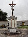
- Wegkreuz Croix St-Nicolas and crossroads of the Rue de la Gare

Statue of Mary and baby Jesus
Memorial to the Fallen

Saint-Nicolas village church

Village school

former train station

one of the wayside crosses

one of the village fountain and church

a decorated door portal
_statue_Vierge_et_Enfant.jpg)
_monument_aux_morts_(en_face),_plaque_1914-18.jpg)
_%C3%A9glise_(01).jpg)
_%C3%A9cole.jpg)
_ce_qui_reste_de_l%27ancienne_gare.jpg)
_croix_de_chemin.jpg)
_fontaine_D.jpg)
_dessus_de_porte.jpg)
Individual evidence
- ↑ Source on the name of the community
- ↑ moving sights
- ↑ Memorial to the Fallen
- ↑ Commemorative plaque for the fallen in the church