
Clayeures
| Clayeures | ||
|---|---|---|

|
|
|
| region | Grand Est | |
| Department | Meurthe-et-Moselle | |
| Arrondissement | Luneville | |
| Canton | Lunéville-2 | |
| Community association | Meurthe Mortagne Moselle | |
| Coordinates | 48 ° 28 ' N , 6 ° 24' E | |
| height | 252-351 m | |
| surface | 9.21 km 2 | |
| Residents | 187 (January 1, 2017) | |
| Population density | 20 inhabitants / km 2 | |
| Post Code | 54290 | |
| INSEE code | 54130 | |
 Mairie Clayeures |
||

Clayeures is a French commune with 187 inhabitants (as of January 1, 2017) in the Meurthe-et-Moselle department in the Grand Est region (before 2016 Lorraine ). It belongs to the arrondissement of Lunéville and the canton of Lunéville-2 (until 2015 the canton of Bayon ).
geography
The municipality is located about 29 kilometers southeast of Nancy in the south of the Meurthe-et-Moselle department. Neighboring communities are Landécourt in the north, Moriviller in the north-east and east, Rozelieures in the south-east, Borville in the south, Froville in the west and Einvaux in the north-west. The community consists of the village of Clayeures and a few individual farms. The river Euron crosses Clayeures.
history
The place was settled early. This was proven by excavations that unearthed finds from the Gallo-Roman period. The current community is indirectly mentioned in 1157 (Ecclesia de Clausuris) in the Latin form Clausuris in a document from the Belchamp Abbey. A first French form appears in a document from Beaupré Abbey as Cleura in 1176. Clayeures historically belonged to the bailiwick (Bailliage) Rosières-aux-Salines and thus to the Duchy of Lorraine , which fell to France in 1766. The place was badly devastated during the Thirty Years War . In 1644 there were only 4 households left. Until the French Revolution , the community was then in the Grand-gouvernement de Lorraine-et-Barrois . From 1793 to 1801 the community was assigned to the Lunéville district. Clayeures was within the canton of Bayon from 1801 to 2015. Since 1801 Clayeures has also been assigned to the Arrondissement of Lunéville. Until 1871, the community was in the old Meurt (h) e. Since then it has been part of the Meurthe-et-Moselle department.
Population development
| year | 1793 | 1851 | 1931 | 1962 | 1968 | 1975 | 1982 | 1990 | 1999 | 2007 | 2016 |
| Residents | 317 | 494 | 214 | 206 | 192 | 184 | 156 | 148 | 153 | 181 | 190 |
| Source: Cassini and INSEE | |||||||||||
traffic
Clayeures is away from major traffic routes. The neighboring municipality of Einvaux has its own stop on the Remiremont-Épinal-Nancy railway line. The D9 (Tanconviller-Lunéville) as a link to the national highways passes a few kilometers north of the municipality. The D122 and D133, which run through the village, are important for regional traffic.
Attractions
- 18th century castle
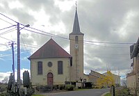
- Saint-Martin village church from the 18th century
- Memorial and plaque for the fallen
- St. Martin Church

Northwest side
Northeast side


Individual evidence
- ↑ Source on the name of the community
- ↑ Memorial to the Fallen
- ↑ Commemorative plaque for the fallen in the church