
Lachapelle (Meurthe-et-Moselle)
| Laughing Chapel | ||
|---|---|---|

|
|
|
| region | Grand Est | |
| Department | Meurthe-et-Moselle | |
| Arrondissement | Luneville | |
| Canton | Baccarat | |
| Community association | Territoire de Lunéville à Baccarat | |
| Coordinates | 48 ° 25 ' N , 6 ° 47' E | |
| height | 269-397 m | |
| surface | 10.17 km 2 | |
| Residents | 266 (January 1, 2017) | |
| Population density | 26 inhabitants / km 2 | |
| Post Code | 54120 | |
| INSEE code | 54287 | |
| Website | http://www.mairie-lachapelle.fr/ | |
_mairie.jpg) Town hall (Mairie) of Lachapelle |
||

Lachapelle is a French commune with 266 inhabitants (as of January 1, 2017) in the Meurthe-et-Moselle department in the Grand Est region (before 2016 Lorraine ). It belongs to the Arrondissement of Lunéville and the Canton of Baccarat .
geography
The municipality is located about 54 kilometers southeast of Nancy in the south of the Meurthe-et-Moselle department on the border with the Vosges department . Neighboring communities are Baccarat in the north, Bertrichamps in the north and north-east, Thiaville-sur-Meurthe in the east and south-east, Sainte-Barbe (in the Vosges department) in the south and south-west and Deneuvre in the west. The community consists of the village and some groups of houses and individual farmsteads. The Meurthe river crosses the municipality and in parts forms the municipality boundary. Large parts of the municipality are forested.
history
The current municipality is mentioned under the Latin name Villa de Capella in a document from the Abbey of Haute-Seille. Lachapelle historically belonged to the province of Trois-Évêchés (Three Dioceses), which in fact fell to France in 1552. Until the French Revolution , the community was then in the Grand-gouvernement de Lorraine-et-Barrois . From 1793 to 1801 the community was assigned to the Lunéville district. It has been part of the canton of Baccarat since 1793. Since 1801, Lachapelle has also been assigned to the Arrondissement of Lunéville. Until 1871, the community was in the old Meurt (h) e. Since then it has been part of the Meurthe-et-Moselle department . Until 1793 the parish was called La Chapelle.
Population development
| year | 1793 | 1836 | 1962 | 1968 | 1975 | 1982 | 1990 | 1999 | 2007 | 2015 | ||
| Residents | 198 | 342 | 123 | 133 | 148 | 143 | 204 | 237 | 239 | 271 | ||
| Source: Cassini and INSEE | ||||||||||||
traffic
Lachapelle is close to the railway line from Lunéville to Saint-Dié-des-Vosges, but does not have its own train station. The nearest stops are in the neighboring communities of Thiaville-sur-Meurthe and Bertrichamps. The N59 runs through the middle of the municipality , but without a direct connection. Places with a full connection not far from Lachapelle are the neighboring communities of Thiaville-sur-Meurthe and Bertrichamps. The D158, which runs through the village, is important for regional traffic.
Attractions
- Saint-Pierre-aux-Liens village church from the 18th century
- Wayside cross / calvary
- Memorial to the Fallen
- two industrial buildings from the 19th century
- five wells; including two covered fountains
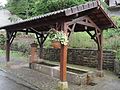
covered well in the parish

Memorial to the Fallen

Saint-Pierre-aux-Liens village church

crossroads
_fontaine_couverte.jpg)
_monument_aux_morts.jpg)
_%C3%A9glise.jpg)
_croix_de_chemin.jpg)