
Bathelémont
| Bathelémont | ||
|---|---|---|

|
|
|
| region | Grand Est | |
| Department | Meurthe-et-Moselle | |
| Arrondissement | Luneville | |
| Canton | Baccarat | |
| Community association | Pays du Sânon | |
| Coordinates | 48 ° 42 ' N , 6 ° 32' E | |
| height | 227-335 m | |
| surface | 6.60 km 2 | |
| Residents | 64 (January 1, 2017) | |
| Population density | 10 inhabitants / km 2 | |
| Post Code | 54370 | |
| INSEE code | 54050 | |
_mairie.jpg) Mairie Bathelémont |
||

Bathelémont is a French commune with 64 inhabitants (as of January 1, 2017) in the Meurthe-et-Moselle department in the Grand Est region . It belongs to the Arrondissement Lunéville and the municipality association Pays du Sânon .
geography
Arracourt is 270 m above sea level, about twelve kilometers north of the city of Lunéville and about 25 kilometers east of the city of Nancy .
The municipality covers a section of the hill country between the Moselle tributaries Sânon in the south and Seille in the north. The northern border of the municipality marks the watershed between the two rivers. Here, in the forest of Bois du Sentier de Vie , the highest point in the municipality is reached at 335 m above sea level. The south-sloping terrain is drained by the Ruisseau de la Fossatte and Ruisseau de Haute Foucray streams towards Sânon. Except for small parts of the forest in the north and fruit trees around the village, large arable areas dominate the area of the community.
Bathelémont's neighboring municipalities are Arracourt in the north, Bures in the east, Hénaménil in the southeast, Bauzemont in the south, Valhey in the southwest and Athienville in the northwest.
history
_(14800169483).jpg)
The name Bathelémont appears for the first time in the late 11th century in a document from Countess Sophia von Bar .
In the Middle Ages the village was divided into two dominions: one part was subject to the Bishop of Metz , the other part belonged to the Duke of Lorraine . In the 18th century, extensive lands around Bathelémont belonged to the House of Ficquelmont , an old noble family from Lorraine. Bathelémont was only reunited with the French Revolution.
In 1917, the first memorial to Americans who died in World War I was erected on French soil in Bathelémont. It was destroyed during the Second World War and later rebuilt.
A second Lorraine municipality called Bathelémont existed until 1806. It was completely absorbed in Laxou , a suburb of Nancy . No longer recorded on any map today, the reason for the suffix -lès-Bauzemont no longer applies , so the Ministry of the Interior approved the application to rename the municipality from Bathelémont-lès-Bauzemont to Bathelémont on March 22, 2011.
Population development
| year | 1962 | 1968 | 1975 | 1982 | 1990 | 1999 | 2007 | 2017 | |
| Residents | 74 | 79 | 71 | 66 | 71 | 65 | 58 | 64 | |
| Sources: Cassini and INSEE | |||||||||
Attractions
- Church of St. John the Baptist ( Église Saint-Jean-Baptiste ), reconstructed after 1918

Saint-Jean-Baptiste church
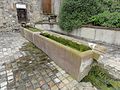
Saint-Jean fountain

one of the wells with a pump
_%C3%A9glise_(02).jpg)
_fontaine_St.Jean.jpg)
_pompe-fontaine.jpg)
Economy and Infrastructure
There are four farms in the municipality (mainly grain cultivation).
Bathelémont is away from the major national traffic flows. To the west of the village runs the trunk road from Lunéville via Moyenvic to Château-Salins . Other roads connect the village with the neighboring communities of Bures and Bauzemont.
Personalities
On February 3, 1753, Jean-Nicolas Stofflet was born in Bathelémont , he was one of the leaders of the Vendée uprising .
supporting documents
- ^ Henri Lepage: Communes de la Meurthe, journal historique des villes, bourgs, villages ... on books.google.fr (French)
- ↑ Monument
- ↑ Decree of the Minister of the Interior ( Memento of the original dated December 13, 2015 in the Internet Archive ) Info: The archive link was inserted automatically and has not yet been checked. Please check the original and archive link according to the instructions and then remove this notice.
- ↑ Bathelémont on cassini.ehess.fr
- ↑ Bathelémont on insee.fr
- ↑ Farms on annuaire-mairie.fr (French)