
Sainte-Pôle
| Sainte-Pôle | ||
|---|---|---|

|
|
|
| region | Grand Est | |
| Department | Meurthe-et-Moselle | |
| Arrondissement | Luneville | |
| Canton | Baccarat | |
| Community association | Vezouze en Piémont | |
| Coordinates | 48 ° 31 ' N , 6 ° 50' E | |
| height | 272-313 m | |
| surface | 5.69 km 2 | |
| Residents | 191 (January 1, 2017) | |
| Population density | 34 inhabitants / km 2 | |
| Post Code | 54540 | |
| INSEE code | 54484 | |
| Website | http://www.sainte-pole.mairie54.fr/ | |
_%C3%A9glise_(02).jpg) Saint-Pélagie village church |
||

Sainte-Pôle is a French commune with 191 inhabitants (as of January 1, 2017) in the Meurthe-et-Moselle department in the Grand Est region (before 2016 Lorraine ). It belongs to the Arrondissement of Lunéville and the Canton of Baccarat (until 2015 the Canton of Badonviller ).
geography
The municipality is located about 51 kilometers southeast of Nancy in the southeast of the Meurthe-et-Moselle department in a plain on the Blette . Neighboring communities are Ancerviller in the north, Saint-Maurice-aux-Forges in the east, Fenneviller and Pexonne in the southeast, Vacqueville in the southwest and Montigny in the west.
history
Sainte-Pôle belonged to the Bailiwick of Lunéville and thus to the Duchy of Lorraine , which fell to France in 1766. In the Thirty Years War the community was badly devastated. Until the French Revolution , the community was then in the Grand-gouvernement de Lorraine-et-Barrois . Serious destruction occurred in the two world wars. From 1793 to 1801 the municipality was assigned to the Blâmont district. Sainte-Pôle changed cantons several times. From 1793 to 1801 it was part of the canton Badouviller (Badonviller). From 1801 to 1879 the community was incorporated into the canton of Baccarat. Then from 1879 to 2015 in the canton of Badonviller. And since then in the canton of Baccarat. Since 1801 it has been assigned to the Lunéville arrondissement. Until 1871, the community was in the old Meurt (h) e. Since then it has been part of the Meurthe-et-Moselle department .
Population development
| year | 1793 | 1836 | 1872 | 1962 | 1968 | 1975 | 1982 | 1990 | 1999 | 2007 | 2015 |
| Residents | 292 | 461 | 418 | 201 | 171 | 150 | 127 | 152 | 178 | 196 | 197 |
| Source: Cassini and INSEE | |||||||||||
traffic
Sainte-Pôle is far from national transport connections. The D168 and the D992, which run through the village, are important for regional traffic.
Attractions
- Saint-Pélagie village church with the Saint-Eloi wooden statue ; destroyed in the First World War and then rebuilt
- Étang sous Launoy pond
- Crossroads on Rue de la Liberation
- Memorial and plaque for the fallen
- Lavoir (wash house)

Étang sous Launoy pond

Memorial to the Fallen
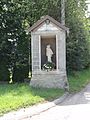
Way chapel / house of prayer
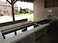
Lavoir (wash house) of Sainte-Pôle
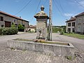
one of the village fountains

_monument_aux_morts.jpg)
_oratoire.jpg)
_lavoir,_int%C3%A9rieur.jpg)
_fontaine_A.jpg)