
Thiébauménil
| Thiébauménil | ||
|---|---|---|

|
|
|
| region | Grand Est | |
| Department | Meurthe-et-Moselle | |
| Arrondissement | Luneville | |
| Canton | Baccarat | |
| Community association | Territoire de Lunéville à Baccarat | |
| Coordinates | 48 ° 35 ' N , 6 ° 37' E | |
| height | 232-293 m | |
| surface | 3.87 km 2 | |
| Residents | 380 (January 1, 2017) | |
| Population density | 98 inhabitants / km 2 | |
| Post Code | 54300 | |
| INSEE code | 54520 | |
 Aerial view of the village |
||

Thiébauménil is a French commune with 380 inhabitants (as of January 1, 2017) in the Meurthe-et-Moselle department in the Grand Est region (before 2016 Lorraine ). It belongs to the Arrondissement of Lunéville and the Canton of Baccarat (until 2015 the Canton of Lunéville-Sud ). The inhabitants call themselves Thiébauménilois (es) .
geography
The municipality is located about 35 kilometers southeast of Nancy in the south of the Meurthe-et-Moselle department. Neighboring municipalities are Laneuveville-aux-Bois and Manonviller in the northeast, Bénaménil in the southeast, Saint-Clément in the south, Moncel-lès-Lunéville in the southwest and Marainviller in the west. The river Vezouze crosses the municipality and in parts forms the municipality boundary.
history
The current community is mentioned for the first time under the name Tibamesni in a document from the Belchamp Abbey in 1152. In the Middle Ages it was temporarily owned by Belchamp Abbey and was badly damaged in the Thirty Years' War . Thiébauménil was historically part of the Duchy of Lorraine , which fell to France in 1766. Until the French Revolution , the community was then in the Grand-gouvernement de Lorraine-et-Barrois . From 1793 to 1801, the community was assigned to the Lunéville district and incorporated into the canton of La Neuveville aux Bois (for a few months earlier, the canton of Bénaménil). Since 1801 it was assigned to the canton of Lunéville-Sud-Est (which became the canton of Lunéville-Sud in 1825) and the arrondissement of Lunéville. The community was in the old Meurte department until 1871. Since then it has been part of the Meurthe-et-Moselle department .
Population development
| year | 1793 | 1846 | 1962 | 1968 | 1975 | 1982 | 1990 | 1999 | 2007 | 2015 |
| Residents | 343 | 514 | 265 | 271 | 237 | 329 | 332 | 360 | 387 | 385 |
| Source: Cassini and INSEE | ||||||||||
traffic
Thiébauménil lies between two railway lines in the direction of the Vosges and Sarrebourg, but does not have its own railway connection. The N4 runs through the middle of the municipality with a full connection to the municipality. The D400, which runs through the village, is important for regional traffic.
Attractions
- Saint-Epvre village church in neo-Gothic style from the 19th century
- some houses from the 18th century
- Memorial to the Fallen

Town hall (mairie) of the municipality
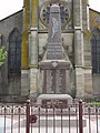
Memorial to the Fallen

Saint-Epvre village church
_mairie.jpg)
_monument_aux_morts.jpg)
_%C3%A9glise.jpg)