
Chazelles-sur-Albe
| Chazelles-sur-Albe | ||
|---|---|---|

|
|
|
| region | Grand Est | |
| Department | Meurthe-et-Moselle | |
| Arrondissement | Luneville | |
| Canton | Baccarat | |
| Community association | Vezouze en Piémont | |
| Coordinates | 48 ° 35 ' N , 6 ° 47' E | |
| height | 251-286 m | |
| surface | 3.39 km 2 | |
| Residents | 44 (January 1, 2017) | |
| Population density | 13 inhabitants / km 2 | |
| Post Code | 54450 | |
| INSEE code | 54124 | |
_city_limit_sign.jpg) Grande Rue of Chazelles-sur-Albe |
||

Chazelles-sur-Albe is a French commune with 44 inhabitants (as of January 1, 2017) in the Meurthe-et-Moselle department in the Grand Est region (before 2016 Lorraine ). It belongs to the Arrondissement of Lunéville and the Canton of Baccarat (until 2015 the Canton of Blâmont ).
geography
The municipality is located about 45 kilometers east-southeast of Nancy in the southeast of the Meurthe-et-Moselle department. The municipality consists of the place Chazelles-sur-Albe. Large parts of the community are forested. The most important forest area is the Bois de la Charbonnière in the north of the municipality. Neighboring municipalities are Gondrexon in the north, Autrepierre in the north-east, Verdenal in the east, Domèvre-sur-Vezouze in the south-east and south, Saint-Martin in the south-west and west, Blémerey in the west and Reillon in the north-west.
history
The place was first mentioned in a document in 1376 under the name Chaizelles . Chazelles-sur-Albe used to belong to the Bailiwick of Blâmont within the province of Trois-Évêchés (Three Dioceses), which in fact fell to France in 1552. Until the French Revolution , the community was then in the Grand-gouvernement de Lorraine-et-Barrois . Chazelles-sur-Albe was largely destroyed during the First World War. From 1793 to 1801, the municipality was assigned to the Blâmont district and part of the Leintrey canton. From 1801 to 2015 it was part of the canton of Blâmont. Since 1801 it has been assigned to the Lunéville arrondissement. Until 1871, the community was in the old Meurt (h) e. Since then it has been part of the Meurthe-et-Moselle department .
Population development
| year | 1793 | 1841 | 1911 | 1921 | 1962 | 1968 | 1975 | 1982 | 1990 | 1999 | 2007 | 2015 |
| Residents | 139 | 190 | 89 | 69 | 56 | 46 | 33 | 35 | 48 | 49 | 46 | 38 |
| Source: Cassini and INSEE | ||||||||||||
traffic
Chazelles-sur-Albe is several kilometers south of the Paris-Strasbourg railway line. The nearest stop is in Avricourt. The N4 runs right through the community . However, the community does not have its own connection. The closest full connections are in Bénaménil and Blâmont. The D162, which runs through the village, is important for regional traffic.
Attractions
- Sainte-Madeleine village church ; rebuilt after 1918
- a wayside cross on Grande Rue west of the village

Mairie (town hall) and village school
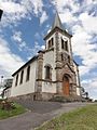
Sainte-Madeleine village church
_mairie_-_%C3%A9cole.jpg)
_%C3%A9glise.jpg)