
Neufmaisons
| Neufmaisons | ||
|---|---|---|

|
|
|
| region | Grand Est | |
| Department | Meurthe-et-Moselle | |
| Arrondissement | Luneville | |
| Canton | Baccarat | |
| Community association | Vezouze en Piémont | |
| Coordinates | 48 ° 28 ' N , 6 ° 51' E | |
| height | 271-539 m | |
| surface | 21.63 km 2 | |
| Residents | 234 (January 1, 2017) | |
| Population density | 11 inhabitants / km 2 | |
| Post Code | 54540 | |
| INSEE code | 54396 | |
 Neufmaisons town hall and school building |
||

Neufmaisons (until 1793 Neuf Maison ) is a French commune with 234 inhabitants (as of January 1, 2017) in the Meurthe-et-Moselle department in the Grand Est region (until 2015 Lorraine ). The municipality belongs to the Arrondissement of Lunéville and the municipality association Vezouze en Piémont, founded in 2016 .
geography
_la_Verdurette.jpg)
Neufmaisons is located at the transition from the flat Lorraine plateau to the foot of the western Vosges , about 35 kilometers southeast of Lunéville and immediately west of the Lac de Pierre-Percée reservoir , which was built for the emergency cooling of the Cattenom nuclear power station 100 kilometers away . About 85% of the 21.63 km² large municipal area is forested. In the Forêt Domaniale des Reclos mountain forest, the Tête des Reclos is the highest point in the municipality at 539 meters above sea level. The Verdurette , a left tributary of the Vezouze, has its source in Neufmaisons . In the southeast, the Plaine river forms the border with the Vosges department . Neufmaisons is surrounded by the neighboring municipalities of Pexonne in the northeast, Pierre-Percée and Celles-sur-Plaine in the southeast, Raon-l'Étape in the south, Bertrichamps in the southwest, Veney in the west and Vacqueville in the northwest.
history
In the 19th century archaeologists found in the forest of Reclos evidence of a Cromlech from the Iron Age with a diameter of thirty steps, also two blocks stacked and regularly aligned blocks. Several fragments of reliefs are said to have been discovered inside the stone circle depicting parts of human bodies, a lion and a vulture. This stone circle was probably the only one in the entire Vosges region. It was destroyed in ignorance of the importance of the construction of forest roads. Today there is no trace of the stone circle left.
The origin of the French name of Neufmaisons (translated: Neunhäuser ) probably dates from around the 12th century, when the village consisted only of nine homes (fireplaces). In the coat of arms, the nine houses are symbolized by nine Alérions .
Until the 19th century, woodworking predominated in New Maisons because of the large forests. The loggers and carters brought the wood to the nearby sawmills; brushes and wooden shoes were made in the village.
Population development
| year | 1962 | 1968 | 1975 | 1982 | 1990 | 1999 | 2007 | 2016 |
| Residents | 354 | 248 | 179 | 178 | 175 | 176 | 224 | 233 |
| Source: Cassini and INSEE | ||||||||
Attractions
- Notre-Dame-du-Mont-Carmel Church ( Mary of Mount Carmel )
- Oratorio
- eight wells
- War memorial
- Monument de la résistance near the Ferme de Viombois : memorial for the resistance fighters killed by the Gestapo in the form of a Lorraine cross

Notre-Dame-du-Mont-Carmel church
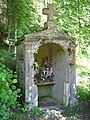
Oratorio in Neufmaisons
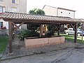
one of the covered fountains in Neufmaisons

War memorial
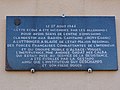
Memorial plaque at the school for the murdered resistance fighters


_fontaine_couverte_(2).jpg)
_monument_aux_morts.jpg)
_plaque_%C3%A9cole,_incendie_guerre.jpg)
Economy and Infrastructure
Two farms are located in Neufmaisons (dairy farming).
Neufmaisons is on the D8 trunk road from Badonviller to Raon-l'Étape . In Raon-l'Étape, eight kilometers away, there is a connection to the motorway-like RN 59 .
supporting documents
- ↑ Neufmaisons on cassini.ehess.fr (French)
- ↑ History abstract on piemontvosgien.fr (French)
- ↑ Neufmaisons on cassini.ehess.fr (French)
- ↑ Neufmaisons on insee.fr
- ↑ Farms on annuaire-mairie.fr (French)