
Drouville
| Drouville | ||
|---|---|---|

|
|
|
| region | Grand Est | |
| Department | Meurthe-et-Moselle | |
| Arrondissement | Luneville | |
| Canton | Lunéville-1 | |
| Community association | Pays du Sânon | |
| Coordinates | 48 ° 40 ′ N , 6 ° 25 ′ E | |
| height | 226-303 m | |
| surface | 7.12 km 2 | |
| Residents | 205 (January 1, 2017) | |
| Population density | 29 inhabitants / km 2 | |
| Post Code | 54370 | |
| INSEE code | 54173 | |
_mairie-%C3%A9cole.jpg) Town hall (Mairie) and village school of the community |
||

Drouville is a French commune with 205 inhabitants (as of January 1, 2017) in the Meurthe-et-Moselle department in the Grand Est region (before 2016 Lorraine ). It belongs to the Arrondissement of Lunéville and the canton of Lunéville-1 (until 2015 the canton of Lunéville-Nord ). The inhabitants call themselves Drouvillois (es) .
geography
The municipality is located about 17 kilometers east-southeast of Nancy in the south of the Meurthe-et-Moselle department. Drouville is on one level and consists of the village of Drouville and a few individual farms. Neighboring communities are Courbesseaux in the northeast, Serres in the east, Maixe in the southeast, Crévic in the south, Haraucourt in the southwest and Gellenoncourt in the west.
history
The place was settled early. This was proven by excavations that brought to light finds from the Gallo-Roman and Merovingian times. Today's community is indirectly mentioned in 1135 (Theodoricus de Drouvilla) under the name Drouvilla in a document from the Beaupré Abbey. In the Middle Ages, the ruling families changed (including the Counts of Mahuet and the Counts of Gâtinois). Due to the Thirty Years' War and the plague, the population sank to only 5 by 1660. In 1712 there were 48 inhabitants again. Drouville belonged to the bailiwick (Bailliage) Lunéville and thus to the Duchy of Lorraine , which fell to France in 1766. Until the French Revolution , the community was then in the Grand-gouvernement de Lorraine-et-Barrois . The place was completely destroyed in the First World War. Including the castle, which was never rebuilt. From 1793 to 1801 the community was assigned to the Lunéville district. Drouville changed cantons several times. From 1793 to 1801 it was part of the canton of Crévic, from 1801 to 2015 of the canton of Lunéville-Nord and since then of the canton of Lunéville-1. Since 1801 Drouville is also assigned to the Arrondissement of Lunéville. Until 1871, the community was in the old Meurt (h) e. Since then it has been part of the Meurthe-et-Moselle department .
Population development
| year | 1793 | 1846 | 1911 | 1921 | 1962 | 1968 | 1975 | 1982 | 1990 | 1999 | 2007 | 2015 |
| Residents | 294 | 470 | 310 | 220 | 164 | 161 | 163 | 158 | 161 | 155 | 164 | 202 |
| Source: Cassini and INSEE | ||||||||||||
traffic
Drouville is far away from national traffic connections. The D70, which runs through the village, is important for regional traffic.
Attractions
- Saint-Martin village church ; Romanesque tower and nave from the 18th century
- Memorial and plaque for the fallen
- Memorial to fallen French soldiers
- Crossroads on the Route d'Haraucourt
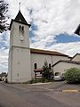
Saint-Martin village church
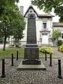
Memorial to the Fallen

Cross in the village cemetery

Memorial to the fallen of Unit 156e RI
_%C3%A9glise_(01).jpg)
_monument_aux_morts.jpg)
_croix_de_cimeti%C3%A8re.jpg)
_m%C3%A9morial_156_RI_,_1914.jpg)
Individual evidence
- ↑ Source on the name of the community
- ↑ Memorial to the Fallen
- ↑ Commemorative plaque for the fallen in the church
- ^ Memorial to fallen French soldiers of Unit 156e RI