
Deuxville
| Deuxville | ||
|---|---|---|

|
|
|
| region | Grand Est | |
| Department | Meurthe-et-Moselle | |
| Arrondissement | Luneville | |
| Canton | Lunéville-1 | |
| Community association | Pays du Sânon | |
| Coordinates | 48 ° 37 ' N , 6 ° 27' E | |
| height | 225-340 m | |
| surface | 7.23 km 2 | |
| Residents | 423 (January 1, 2017) | |
| Population density | 59 inhabitants / km 2 | |
| Post Code | 54370 | |
| INSEE code | 54155 | |
_m%C3%A9morial_de_L%C3%A9omont_(05)_vue_sur_Deuxville.jpg) View of Deuxville |
||

Deuxville is a French commune with 423 inhabitants (as of January 1, 2017) in the Meurthe-et-Moselle department in the Grand Est region (before 2016 Lorraine ). It belongs to the Arrondissement of Lunéville and the canton of Lunéville-1 (until 2015 the canton of Lunéville-Nord ). The inhabitants call themselves Deuxvillois (es) .
geography
The municipality is located about 22 kilometers southeast of Nancy in the south of the Meurthe-et-Moselle department. Neighboring communities are Einville-au-Jard in the northeast, Bonviller in the east, Lunéville in the east and southeast, Vitrimont in the southwest, Anthelupt in the west and Maixe in the northwest. The community consists of the village of Deuxville, the hamlets of Le Mouton Noir and Saint-Epvre and some individual farms. The Ruisseau de Deuxville flows north through the municipality . It used to separate the parishes of Deuxville Notre-Dame (-de-la-Outre) and Deuxville-Saint-Epvre.
history
The place was settled early. This was proven by excavations that unearthed finds from the Gallo-Roman period. Today's community is first mentioned in a document in 1147 under the name Deuvile . The ruling families changed in the Middle Ages. During the Thirty Years War , the parishes of Deuxville and Saint-Epvre were completely destroyed by troops passing through. Not a single resident survived this war. Even in 1660 there were only 4 people left in Deuxville. Saint-Epvre remained desolate. It was not until the late 17th and early 18th centuries that Deuxville was repopulated. The municipality historically belonged to the bailiwick (Bailliage) Lunéville and thus to the Duchy of Lorraine , which fell to France in 1766. Until the French Revolution , the community was then in the Grand-gouvernement de Lorraine-et-Barrois . From 1793 to 1801 the community was assigned to the Lunéville district and the Lunéville canton. From 1801 to 2015 it was part of the canton of Lunéville-Nord and has been within the canton of Lunéville-1 since then. Since 1801, Deuxville is also assigned to the Arrondissement of Lunéville. Until 1871, the community was in the old Meurt (h) e. Since then it has been part of the Meurthe-et-Moselle department .
Population development
| year | 1793 | 1846 | 1911 | 1921 | 1962 | 1968 | 1975 | 1982 | 1990 | 1999 | 2007 | 2017 |
| Residents | 316 | 571 | 399 | 335 | 304 | 273 | 288 | 270 | 312 | 364 | 394 | 423 |
| Sources: Cassini and INSEE | ||||||||||||
traffic
Deuxville is close to the Lunéville-Nancy railway line. There is a train station in the neighboring municipality. The N333 (regional part of the N4 Paris-Nancy-Strasbourg) runs right through the municipality. The next full connection is in Chaufontaine in the municipality of Rehainviller. The D97, which runs through the village, is important for regional traffic.
Attractions
- Saint-Epvre village church , rebuilt after the First World War
- Memorial to the Fallen
- Memorial with military cemetery for the fallen of the 79e and 279e RI units in Friscati
- two wayside crosses (on the Route de Vitrimont and on the Rue de Lunéville)

Town hall (Mairie) of the municipality
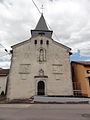
Saint-Epvre village church

Memorial to the Fallen

crossroads

Memorial to the fallen of Units 79e and 279e RI

Village school
_mairie.jpg)
_%C3%A9glise_(01).jpg)
_Monument_aux_morts_au_cimeti%C3%A8re.jpg)
_croix_de_chemin.jpg)
_m%C3%A9morial_79_RID.jpg)
_%C3%A9cole.jpg)