
Halloville
| Halloville | ||
|---|---|---|

|
|
|
| region | Grand Est | |
| Department | Meurthe-et-Moselle | |
| Arrondissement | Luneville | |
| Canton | Baccarat | |
| Community association | Vezouze en Piémont | |
| Coordinates | 48 ° 33 ' N , 6 ° 52' E | |
| height | 262–333 m | |
| surface | 3.93 km 2 | |
| Residents | 71 (January 1, 2017) | |
| Population density | 18 inhabitants / km 2 | |
| Post Code | 54450 | |
| INSEE code | 54246 | |
_vue_du_village.jpg) View of Halloville |
||

Halloville is a French commune with 71 inhabitants (as of January 1, 2017) in the Meurthe-et-Moselle department in the Grand Est region (before 2016 Lorraine ). It belongs to the Arrondissement of Lunéville and the Canton of Baccarat (until 2015 the Canton of Blâmont ).
geography
The municipality is located about 52 kilometers southeast of Nancy in the southeast of the Meurthe-et-Moselle department. Large areas of the community are forested. Neighboring communities are Harbouey in the northeast, Nonhigny in the east, Montreux in the southeast, Ancerviller in the southwest and west and Barbas in the northwest.
history
In a purchase agreement from 1363, the ruler from the House of Habsburg sells half of the Halewiler community to the Count of Salm. This is the first mention of the Halloville Ward. This was thus divided in the Hundred Years War . Part of today's community was under the Bailiwick of Vic and historically belonged to the province of Trois-Évêchés (Three Bishoprics), which in fact fell to France in 1552. The other part of the municipality belonged legally to the Bailiwick of Blâmont and thus to the Duchy of Lorraine , which fell to France in 1766. Until the French Revolution , the community was then in the Grand-gouvernement de Lorraine-et-Barrois . In the Thirty Years War the community was completely destroyed. Not a single resident survived. Halloville was not repopulated until after 1700. There was destruction in the two world wars. During the First World War, a German bombardment on August 9 and 10, 1914, caused severe damage to the community. Further artillery attacks on both sides caused damage. The village was rebuilt after the First World War instead of on the hill below in the valley floor. From 1793 to 1801 the municipality was assigned to the Blâmont district. And incorporated into the canton of Blâmont from 1793 to 2015. Since then it has been part of the canton of Baccarat. Halloville has been part of the Lunéville arrondissement since 1801. Until 1871, the community was in the old Meurt (h) e. Since then it has been part of the Meurthe-et-Moselle department .
Population development
| year | 1793 | 1806 | 1962 | 1968 | 1975 | 1982 | 1990 | 1999 | 2007 | 2015 |
| Residents | 148 | 190 | 80 | 81 | 75 | 62 | 63 | 59 | 65 | 76 |
| Source: Cassini and INSEE | ||||||||||
traffic
Halloville is close to national transport links. The railway lines are further away than national motorways. The nearest stops are Igney-Avricourt on the Paris – Strasbourg line and Baccarat on the Lunéville to Saint-Dié-des-Vosges line. The N4 passes just a few kilometers north of the municipality . The closest connection is in Blâmont. The D20B, which runs through the village, is important for regional traffic.
Attractions
- Saint-Georges village church ; rebuilt after the First World War
- several lavoirs (wash houses) and village wells
- two wayside crosses
- Memorial to the Fallen
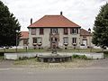
Town hall (Mairie) of the municipality
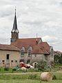
Saint-Georges village church

Memorial to the Fallen

one of the two wayside crosses

One of three village fountains
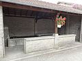
one of the three lavoirs
_mairie.jpg)
_%C3%A9glise_(01).jpg)
_monument_aux_morts_devant_la_mairie.jpg)
_croix_de_chemin_B.jpg)
_fontaine_C.jpg)
_lavoir_C.jpg)