
Domjevin
| Domjevin | ||
|---|---|---|

|
|
|
| region | Grand Est | |
| Department | Meurthe-et-Moselle | |
| Arrondissement | Luneville | |
| Canton | Baccarat | |
| Community association | Vezouze en Piémont | |
| Coordinates | 48 ° 35 ' N , 6 ° 42' E | |
| height | 237-293 m | |
| surface | 10.28 km 2 | |
| Residents | 256 (January 1, 2017) | |
| Population density | 25 inhabitants / km 2 | |
| Post Code | 54450 | |
| INSEE code | 54163 | |

Domjevin is a French commune with 256 inhabitants (as of January 1, 2017) in the Meurthe-et-Moselle department in the Grand Est region (before 2016 Lorraine ). It belongs to the Arrondissement of Lunéville and the Canton of Baccarat (until 2015 the Canton of Blâmont ). The residents call themselves Domjevinois (es) .
geography

The municipality is located about 40 kilometers east-southeast of Nancy in the southeast of the Meurthe-et-Moselle department on the Vezouze river . Neighboring communities are Vého in the north, Reillon in the northeast, Blémerey in the east, Fréménil in the southeast, Bénaménil in the southwest and Manonviller in the northwest. The community consists of Domjevin and a few homesteads.
history
The present-day community is indirectly mentioned in 1124 (Rainerus de Domno Juvino) under the Latin name Domno Juvino for the first time in a document. The French form first appeared as Domjuvin in 1189. In the 13th century there was a later destroyed monastery community of the Templars. In 1308, attackers from Metz completely destroyed Domjevin and Frisonviller (in what is now the municipality). Frisonviller is no longer being rebuilt. Domjevin subordinates itself to the Duchy of Lorraine in 1329 . It then belonged to the Bailiwick of Lunéville and fell to France in 1766. Between 1584 and 1630, 16 residents of the parish were executed for witchcraft . The Thirty Years' War and the plague killed all but 30 people. Until the French Revolution , the community was then in the Grand-gouvernement de Lorraine-et-Barrois . There was destruction in the two world wars. In the Second World War alone, 30,000 shells fell on the village. From 1793 to 1801 the community was assigned to the Lunéville district. From 1793 to 1801 it was part of the canton of La Neuveville aux Bois. From 1801 to 2015, the municipality was incorporated into the canton of Blâmont. Since 1801 it has been assigned to the Lunéville arrondissement. Until 1871, the community was in the old Meurt (h) e. Since then it has been part of the Meurthe-et-Moselle department .
Population development
| year | 1793 | 1836 | 1911 | 1921 | 1962 | 1968 | 1975 | 1982 | 1990 | 1999 | 2007 | 2015 |
| Residents | 496 | 601 | 411 | 311 | 296 | 257 | 237 | 228 | 230 | 267 | 240 | 255 |
| Source: Cassini and INSEE | ||||||||||||
traffic
Domjevin is located south of the Paris-Strasbourg railway line and does not have its own stop. The closest stops are in Marainviller and Emberménil. The N4 runs right through the community . The closest connection is in Bénaménil. The D19 and D163, which run through the village, are important for regional traffic.
Attractions
- Saint-Juvin village church
- numerous door portals from the 18th and 19th centuries that are well worth seeing
- Notre-Dame de la Bonne Fontaine chapel (rebuilt after the Second World War)
- several wayside crosses (including Croix blanche and Croix du center )
- Monuments to the Fallen
- Remains of the military hospital
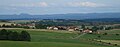
View of the community and its surroundings
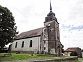
Saint-Juvin village church

Memorial to the Fallen
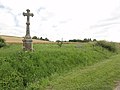
crossroads
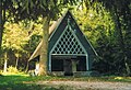
Today's Notre-Dame de la Bonne Fontaine chapel

Remains of the military hospital

Military cemetery in the village cemetery

beautiful entrance
_%C3%A9glise_(01).jpg)

_croix_de_chemin.jpg)


_cimeti%C3%A8re,_carr%C3%A9_militiaire.jpg)
_porte_maison_B.jpg)
Individual evidence
- ↑ Source on the name of the community
- ↑ moving sights
- ↑ Memorial to the Fallen
- ^ Memorial to the fallen in the village cemetery