
Courbesseaux
| Courbesseaux | ||
|---|---|---|

|
|
|
| region | Grand Est | |
| Department | Meurthe-et-Moselle | |
| Arrondissement | Luneville | |
| Canton | Lunéville-1 | |
| Community association | Pays du Sânon | |
| Coordinates | 48 ° 41 ′ N , 6 ° 24 ′ E | |
| height | 217-293 m | |
| surface | 6.32 km 2 | |
| Residents | 337 (January 1, 2017) | |
| Population density | 53 inhabitants / km 2 | |
| Post Code | 54110 | |
| INSEE code | 54139 | |
| Website | http://courbesseaux.net/topic/index.html | |
_vue_du_village.jpg) View of Courbesseaux |
||

Courbesseaux is a French commune with 337 inhabitants (as of January 1, 2017) in the Meurthe-et-Moselle department in the Grand Est region (before 2016 Lorraine ). It belongs to the Arrondissement of Lunéville and the canton of Lunéville-1 (until 2015 the canton of Lunéville-Nord ). The inhabitants call themselves Curvasalissiens / Curvasalissiennes .
geography
The parish is located about 16 kilometers east of Nancy . Neighboring municipalities are Hoéville in the north-east, Serres in the east and south-east, Drouville in the south, Gellenoncourt in the south-west and Réméréville in the west, north-west and north.
history
The present municipality is mentioned for the first time in a document in the 13th century under the name Corbesal . The ruling families changed in the Middle Ages. In 1631 the plague struck Courbesseaux. The municipality historically belonged to the Duchy of Lorraine , which fell to France in 1766. Until the French Revolution , the community was then in the Grand-gouvernement de Lorraine-et-Barrois . During the First World War, the site was completely destroyed during the Battle of the Grand Couronné (September 4 to 13, 1914). From 1793 to 1801 the community was assigned to the Lunéville district. Courbesseaux changed cantons several times. From 1793 to 1801 it was part of the canton of Crévic, from 1801 to 2015 of the canton of Lunéville-Nord and since then of the canton of Lunéville-1. Since 1801 Courbesseaux is also assigned to the Arrondissement of Lunéville. Until 1871, the community was in the old Meurt (h) e. Since then it has been part of the Meurthe-et-Moselle department .
Population development
| year | 1793 | 1846 | 1962 | 1968 | 1975 | 1982 | 1990 | 1999 | 2007 | 2015 |
| Residents | 192 | 365 | 101 | 96 | 127 | 187 | 184 | 190 | 233 | 323 |
| Source: Cassini and INSEE | ||||||||||
traffic
Courbesseaux is far away from national transport connections. The D70 and D80, which run through the village, are important for regional traffic.
Attractions
- Sainte-Croix village church from the 18th century; rebuilt after the First World War
- Commemorative plaques for the fallen
- National cemetery (Nécropole) for French soldiers who fell in the Battle of the Grand Couronné (September 4 to 13, 1914)
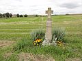
- Wayside cross on rue du Général de Castelnau

National cemetery (Nécropole) north of Courbesseaux

Town hall (Mairie) of the municipality

Sainte-Croix village church
crossroads

Cross in the village cemetery

Bridge over the Roanne
_n%C3%A9cropole_nationale_Courbesseaux_(04).jpg)
_mairie.jpg)
_%C3%A9glise_(02).jpg)
_paysage_avec_croix_de_chemin.jpg)
_cimeti%C3%A8re_communal,_croix.jpg)
_pont_sur_ruisseau_La_Roanne.jpg)
Individual evidence
- ↑ Source on the name of the community
- ↑ Commemorative plaques for the fallen
- ^ Memorial to French soldiers who fell in the Battle of the Grand Couronné
- ↑ Pictures and brief information in French