
Autrepierre
| Autrepierre | ||
|---|---|---|

|
|
|
| region | Grand Est | |
| Department | Meurthe-et-Moselle | |
| Arrondissement | Luneville | |
| Canton | Baccarat | |
| Community association | Vezouze en Piémont | |
| Coordinates | 48 ° 37 ' N , 6 ° 48' E | |
| height | 254-346 m | |
| surface | 7.75 km 2 | |
| Residents | 82 (January 1, 2017) | |
| Population density | 11 inhabitants / km 2 | |
| Post Code | 54450 | |
| INSEE code | 54030 | |
_mairie_-_%C3%A9cole.jpg) Mairie (Town Hall) of the parish |
||

Autrepierre is a French commune with 82 inhabitants (as of January 1, 2017) in the Meurthe-et-Moselle department in the Grand Est region (before 2016 Lorraine ). It belongs to the Arrondissement of Lunéville and the Canton of Baccarat (until 2015 the Canton of Blâmont ).
geography
The municipality is located about 38 kilometers east-southeast of Nancy . Neighboring communities are Amenoncourt in the north, Igney in the northeast, Repaix in the east, Verdenal in the south, Chazelles-sur-Albe in the southwest, Gondrexon in the west and Leintrey in the northwest.
Population development
| year | 1793 | 1851 | 1962 | 1968 | 1975 | 1982 | 1990 | 1999 | 2006 | 2015 |
| Residents | 258 | 333 | 152 | 157 | 161 | 133 | 113 | 108 | 117 | 81 |
| Source: Cassini and INSEE | ||||||||||
traffic
The RN4 passes the community a few kilometers south.
Attractions
- Saint-Clément village church from the 18th century
- Crossroads
- Fountain

Saint-Clément church

Wayside cross
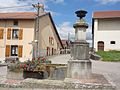
Fountain
_%C3%A9glise.jpg)
_croix_de_chemin_A.jpg)
_fontaine_haute.jpg)
Individual evidence
Web links
Commons : Autrepierre - collection of images, videos and audio files