
Charmois (Meurthe-et-Moselle)
| Charmois | ||
|---|---|---|

|
|
|
| region | Grand Est | |
| Department | Meurthe-et-Moselle | |
| Arrondissement | Luneville | |
| Canton | Lunéville-2 | |
| Community association | Meurthe Mortagne Moselle | |
| Coordinates | 48 ° 32 ' N , 6 ° 23' E | |
| height | 230-288 m | |
| surface | 5.41 km 2 | |
| Residents | 190 (January 1, 2017) | |
| Population density | 35 inhabitants / km 2 | |
| Post Code | 54360 | |
| INSEE code | 54121 | |
_vue_de_Charmois.jpg) View of Charmois |
||

Charmois is a French commune with 190 inhabitants (as of January 1, 2017) in the Meurthe-et-Moselle department in the Grand Est region (before 2016 Lorraine ). It belongs to the arrondissement of Lunéville and the canton of Lunéville-2 (until 2015 the canton of Bayon ). The inhabitants call themselves Charmoyens / Charmoyennes .
geography
The municipality is located about 22 kilometers southeast of Nancy in the south of the Meurthe-et-Moselle department. Neighboring communities are Damelevières in the north, Blainville-sur-l'Eau in the east and south-east, Méhoncourt in the south and Barbonville in the west and north-west. The Ruisseau de Chaufontaine stream crosses Charmois. Large parts of the municipality in the south of the municipality are covered by forest.
history
The current community is indirectly mentioned in 1157 (Alodium de Charmeyaco) in the Latin form Charmeyaco for the first time in a document from the Belchamp Abbey. A first French form appears in a document as Chermoy in the same year. Charmois historically belonged to the Vogtei (Bailliage) Rosières-aux-Salines and thus to the Duchy of Lorraine , which fell to France in 1766. Until the French Revolution , the community was then in the Grand-gouvernement de Lorraine-et-Barrois . From 1793 to 1801 the community was assigned to the Lunéville district. Charmois changed cantons several times. From 1793 to 1801 it was part of the canton of Blainville, from 1801 to 2015 of the canton of Bayon and since then of the canton of Lunéville-2. Since 1801 Charmois has also been assigned to the Arrondissement of Lunéville. Until 1871, the community was in the old Meurt (h) e. Since then it has been part of the Meurthe-et-Moselle department.
Population development
| year | 1793 | 1851 | 1911 | 1921 | 1962 | 1968 | 1975 | 1982 | 1990 | 1999 | 2007 | 2015 |
| Residents | 70 | 144 | 109 | 81 | 110 | 103 | 116 | 160 | 196 | 183 | 155 | 186 |
| Source: Cassini and INSEE | ||||||||||||
traffic
Charmois is close to major transport routes. The Nancy-Épinal-Remiremont railway runs straight through the municipality. But Charmois does not have its own stop. In the neighboring municipality of Damelevières there is a stop on the Nancy-Épinal-Remiremont and Paris-Nancy-Strasbourg lines. The N333 (regional part of the N4 Paris-Nancy-Strasbourg) passes a few kilometers north of the municipality. The closest connections are Chaufontaine in the municipality of Rehainviller, Hudiviller and Dombasle-sur-Meurthe. The D1c, which runs through the village, is important for regional traffic.
Attractions
- Cross in the village cemetery
- Bell tower of the former village church
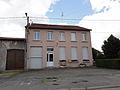
Town hall (Mairie) of the municipality

Cross in the village cemetery
_mairie.jpg)
_croix_de_cimeti%C3%A8re.jpg)