
Reillon
| Reillon | ||
|---|---|---|

|
|
|
| region | Grand Est | |
| Department | Meurthe-et-Moselle | |
| Arrondissement | Luneville | |
| Canton | Baccarat | |
| Community association | Vezouze en Piémont | |
| Coordinates | 48 ° 36 ' N , 6 ° 45' E | |
| height | 247-292 m | |
| surface | 4.39 km 2 | |
| Residents | 87 (January 1, 2017) | |
| Population density | 20 inhabitants / km 2 | |
| Post Code | 54450 | |
| INSEE code | 54452 | |
_city_limit_sign.jpg) Main street (Grande Rue) of the parish |
||

Reillon is a French commune with 87 inhabitants (as of January 1, 2017) in the Meurthe-et-Moselle department in the Grand Est region (before 2016 Lorraine ). It belongs to the Arrondissement of Lunéville and the Canton of Baccarat (until 2015 the Canton of Blâmont ).
geography
The municipality is located about 42 kilometers east-southeast of Nancy in the southeast of the Meurthe-et-Moselle department. Neighboring municipalities are Leintrey in the north, Gondrexon in the east, Chazelles-sur-Albe in the southeast, Blémerey in the south, Domjevin in the southwest and Vého in the west.
history
The present parish is first mentioned in a document in 1293 under the name Rullons . In 1604, Marguerite François was burned as a witch. Reillon was part of the Vogtei (Bailliage) Blâmont and thus historically belonged to the Duchy of Lorraine , which fell to France in 1766. Until the French Revolution , the community was then in the Grand-gouvernement de Lorraine-et-Barrois . From 1793 to 1801 Reillon was assigned to the district of Blâmont and the canton of Leintrey. From 1801 to 2015, the municipality was in the canton of Blâmont and has been part of the canton of Baccarat ever since. Reillon has been part of the Lunéville arrondissement since 1801. Until 1871, the community was in the old Meurt (h) e. Since then it has been part of the Meurthe-et-Moselle department. During the First World War, the parish was completely destroyed except for the Calvary near the church.
Population development
| year | 1793 | 1846 | 1911 | 1921 | 1962 | 1968 | 1975 | 1982 | 1990 | 1999 | 2007 | 2015 |
| Residents | 120 | 195 | 96 | 45 | 63 | 54 | 64 | 83 | 87 | 72 | 71 | 78 |
| Source: Cassini and INSEE | ||||||||||||
traffic
Reillon is close to major national transport routes. The municipality is located south of the Paris-Strasbourg railway line. The nearest stop is in Emberménil. The N4 passes a few kilometers south . The closest connection is in Bénaménil. The D162, which runs right through the village, is important for regional traffic.
Attractions
- Village church Église de la Nativité-de-la-Vierge , rebuilt after the First World War
- Two military cemeteries from the First World War. There are the graves of 5500 German and 1400 French soldiers
- Calvary from 1604, the only vestige of the old village
- Crossroads on Grande Rue

Town hall (Mairie) and village school of the community

Village church Église de la Nativité-de-la-Vierge
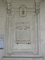
Memorial to the fallen at the entrance to the town hall

one of the two wayside crosses

National cemetery (Nécropole) east of the village
_mairie_-_%C3%A9cole.jpg)
_%C3%A9glise_(02).jpg)
_plaque_monument_aux_morts_sur_la_mairie.jpg)
_croix_de_chemin_B.jpg)
_n%C3%A9cropole_nationale_(02).jpg)