Domèvre-sur-Vezouze
| Domèvre-sur-Vezouze | ||
|---|---|---|

|
|
|
| region | Grand Est | |
| Department | Meurthe-et-Moselle | |
| Arrondissement | Luneville | |
| Canton | Baccarat | |
| Community association | Vezouze en Piémont | |
| Coordinates | 48 ° 34 ' N , 6 ° 48' E | |
| height | 246-317 m | |
| surface | 14.78 km 2 | |
| Residents | 296 (January 1, 2017) | |
| Population density | 20 inhabitants / km 2 | |
| Post Code | 54450 | |
| INSEE code | 54161 | |
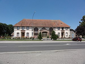
 Town hall ( Mairie ) of the municipality |
||
Domèvre-sur-Vezouze is a French commune with 296 inhabitants (as of January 1, 2017) in the Meurthe-et-Moselle department in the Grand Est region (before 2016 Lorraine ). It belongs to the Arrondissement of Lunéville and the Canton of Baccarat (until 2015 the Canton of Blâmont ).
geography
The municipality is located about 48 kilometers southeast of Nancy in the south of the Meurthe-et-Moselle department. Neighboring municipalities are Verdenal in the north, Blâmont in the northeast, Barbas in the east, Ancerviller in the southeast, Mignéville in the south and southwest, Herbéviller and Saint-Martin in the west and Chazelles-sur-Albe in the northwest. The river Vezouze crosses the municipality and in parts forms the municipality boundary. Large parts of the municipality are covered by forest.
history
The current community is first mentioned in a document in the 13th century under the Latin name Ecclesia Domni Apri . In 1479, the name Domepvre appears in a collection of documents from the Blâmont fiefdom . Until the destruction of the Saint-Sauveur abbey in 1588, the place was under this abbey. From 1588 until the French Revolution, the monks lived in the local abbey. The place was called Domèvre-l'Abbaye until 1791. During the Thirty Years War , the community was almost completely destroyed by French troops. Bad harvests and the plague also reduced the number of residents. Domèvre-sur-Vezouze legally belonged to the Bailiwick of Blâmont and thus to the Duchy of Lorraine , which fell to France in 1766. Until the French Revolution , the community was then in the Grand-gouvernement de Lorraine-et-Barrois . During the troubled times of the French Revolution, the abbey was looted and destroyed. Destruction again occurred in the two world wars. From 1793 to 1801 the municipality was assigned to the Blâmont district. From 1793 to 2015 Domèvre-sur-Vezouze was incorporated into the canton of Blâmont. Since 1801 it has been assigned to the Lunéville arrondissement. The community was in the old Meurte department until 1871. Since then it has been part of the Meurthe-et-Moselle department . Until 1936 the municipality was called Domèvre (also Domevre).
Population development
| year | 1793 | 1831 | 1911 | 1921 | 1962 | 1968 | 1975 | 1982 | 1990 | 1999 | 2007 | 2015 |
| Residents | 960 | 1306 | 671 | 431 | 337 | 301 | 294 | 261 | 227 | 231 | 288 | 289 |
| Source: Cassini and INSEE | ||||||||||||
traffic
The N4 passes north of Domèvre-sur-Vezouze . The closest connection is in Blâmont. The D400, which runs through the village, is important for regional traffic.
Attractions
- 19th century castle
- Saint-Epvre village church from 1743
- Memorial and plaque for the fallen
Individual evidence
- ↑ Source on the name of the community
- ↑ moving sights
- ↑ Memorial to the Fallen
- ↑ Commemorative plaque for fighters of the Resistance


