Xures
| Xures | ||
|---|---|---|

|
|
|
| region | Grand Est | |
| Department | Meurthe-et-Moselle | |
| Arrondissement | Luneville | |
| Canton | Baccarat | |
| Community association | Pays du Sânon | |
| Coordinates | 48 ° 41 ′ N , 6 ° 39 ′ E | |
| height | 225-280 m | |
| surface | 6.98 km 2 | |
| Residents | 108 (January 1, 2017) | |
| Population density | 15 inhabitants / km 2 | |
| Post Code | 54370 | |
| INSEE code | 54601 | |
 Mairie and school in Xures |
||
Xures is a French commune with 108 inhabitants (as of January 1, 2017) in the Meurthe-et-Moselle department in the Grand Est region (until 2015 Lorraine ). It belongs to the Arrondissement Lunéville and the municipality association Pays du Sânon .
geography
Xures is at 240 m above sea level, about halfway between Nancy and Sarrebourg and about 20 kilometers northeast of Lunéville . In the north and east, the area of the municipality borders on the Moselle department .
The community area covers a section of the upper Sânon valley. The Rhine-Marne Canal runs parallel to the Sânon . The southern third of the almost 7 km² large municipal area is forested ( Bois de Xures ). The terrain gradually rises to the south and north-east; it reaches the highest altitude at the northeastern municipal boundary at 280 m above sea level. A log house stood here until the First World War .
The hamlet of Le Prieure, north of the town center, belongs to Xures .
Neighboring municipalities of Xures are Moncourt in the north, Lagarde in the east, Emberménil in the south, Mouacourt in the west and Coincourt in the northwest.
history
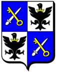
The sword and key in the coat of arms of Xures are a reminder of belonging to the Senones Abbey in the Ancien Régime .
Xures was on the border with the German Empire from 1871 to 1914. With the beginning of the First World War, the border village was completely cleared. When German troops withdrew during World War II, all 115 residents of Xures were deported to Germany in 1944, 25 of whom died.
On January 1, 1973, Xures was incorporated into Parroy together with the neighboring towns of Coincourt and Mouacourt . This parish merger was canceled on January 1, 1987.
Population development
| year | 1946 | 1954 | 1962 | 1968 | 1990 | 1999 | 2007 | 2016 |
| Residents | 170 | 203 | 166 | 173 | 104 | 121 | 133 | 111 |
| Sources: Cassini and INSEE | ||||||||
Attractions
- Church of St. Christophorus ( Église Saint-Christophe )
- Fallen memorial
- Ship berth on the Rhine-Marne Canal
Economy and Infrastructure
Four farms are located in Xures (grain cultivation, cattle breeding).
The trunk road from Dombasle-sur-Meurthe leads through the municipality of Xures via Lagarde towards Sarrebourg . Other roads connect the village with the municipalities of Vaucourt and Moncourt . In the municipality of Thiébauménil , 20 kilometers to the south, there is a connection to the motorway-like RN 4 from Nancy to Strasbourg .

