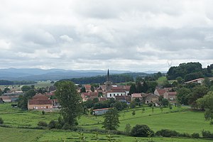
Barbas
| Barbas | ||
|---|---|---|

|
|
|
| region | Grand Est | |
| Department | Meurthe-et-Moselle | |
| Arrondissement | Luneville | |
| Canton | Baccarat | |
| Community association | Vezouze en Piémont | |
| Coordinates | 48 ° 34 ' N , 6 ° 51' E | |
| height | 257-319 m | |
| surface | 7.33 km 2 | |
| Residents | 191 (January 1, 2017) | |
| Population density | 26 inhabitants / km 2 | |
| Post Code | 54450 | |
| INSEE code | 54044 | |
 Look at Barbas |
||
Barbas is a French commune with 191 inhabitants (as of January 1, 2017) in the Meurthe-et-Moselle department in the Grand Est region (until 2015 Lorraine ). It belongs to the Arrondissement Lunéville and the municipality association Vezouze en Piémont .
geography
The municipality of Barbas is located about 20 kilometers southwest of Sarrebourg and 20 kilometers east of Lunéville in the western foreland of the northern Vosges . The Vacon , a left tributary of the Vezouze, flows through the 7.33 km² municipal area .
Neighboring communities of Barbas are Blâmont in the north, Harbouey in the east, Halloville and Ancerviller in the south and Domèvre-sur-Vezouze in the west.
history
coat of arms
The coat of arms of the former rule of Barbas, a former knight family, acts as the municipal coat of arms.
Population development
| year | 1962 | 1968 | 1975 | 1982 | 1990 | 1999 | 2006 | 2017 | |
| Residents | 172 | 162 | 142 | 129 | 141 | 145 | 139 | 191 | |
| Sources: Cassini and INSEE | |||||||||
Attractions
- Church of St. Luke ( Église Saint-Luc ), rebuilt after being destroyed in 1918
Economy and Infrastructure
There are seven farms in the municipality (dairy farming, cattle breeding, sheep and goats).
The D 20 trunk road from Badonviller to Blâmont runs through the municipality of Barbas . Four kilometers north of Barbas there is a connection to the motorway-like RN 4 from Nancy to Strasbourg . Nouvel Avricourt station, 13 kilometers from Barbas, is on the Paris – Strasbourg line .
