
Ogéviller
| Ogéviller | ||
|---|---|---|

|
|
|
| region | Grand Est | |
| Department | Meurthe-et-Moselle | |
| Arrondissement | Luneville | |
| Canton | Baccarat | |
| Community association | Vezouze en Piémont | |
| Coordinates | 48 ° 33 ' N , 6 ° 44' E | |
| height | 241-282 m | |
| surface | 3.54 km 2 | |
| Residents | 283 (January 1, 2017) | |
| Population density | 80 inhabitants / km 2 | |
| Post Code | 54450 | |
| INSEE code | 54406 | |
_mairie.jpg) Town hall ( Mairie ) of the municipality |
||

Ogéviller is a French commune with 283 inhabitants (as of January 1, 2017) in the Meurthe-et-Moselle department in the Grand Est region (before 2016 Lorraine ). It belongs to the Arrondissement of Lunéville and the Canton of Baccarat (until 2015 the Canton of Blâmont ). The inhabitants call themselves Ogévillois (es) .
geography
The municipality is located about 43 kilometers southeast of Nancy in the south of the Meurthe-et-Moselle department. Neighboring municipalities are Herbéviller in the northeast and east, Réclonville in the southeast, Buriville in the southwest and west and Fréménil in the northwest. The Verdurette river crosses the municipality and in parts forms the municipal boundary.
history
The present-day community is first mentioned in 1152 under the Latin name Ogeriivillare cum ecclesia in a document from Senones Abbey. The name Ogieviler appears in a collection of documents in 1301 . A castle was built in the 12th century at the latest. Various feudal lords administered the place from this castle. The place and the castle were taken in 1587 by German horsemen under the command of the Duke de Bouillon. Cardinal Richelieu ordered the dismantling of all military fortifications. In 1635 the castle and town were badly devastated in the Thirty Years' War . Ogéviller belonged to the Bailiwick of Lunéville and thus to the Duchy of Lorraine , which fell to France in 1766. Until the French Revolution , the community was then in the Grand-gouvernement de Lorraine-et-Barrois . During the troubled times of the French Revolution, the remains of the castle were looted and the stones were used for private buildings. Destruction again occurred in the two world wars. From 1793 to 1801 the municipality was assigned to the Blâmont district. From 1793 to 1801 Ogéviller was the capital of a canton. From 1801 to 2015, the municipality was incorporated into the canton of Blâmont. Since 1801 it has been assigned to the Lunéville arrondissement. The community was in the old Meurte department until 1871. Since then it has been part of the Meurthe-et-Moselle department . Earlier name variants for Ogéviller were Juviller and Ogeviller in the 19th century .
Population development
| year | 1793 | 1831 | 1936 | 1946 | 1962 | 1968 | 1975 | 1982 | 1990 | 1999 | 2007 | 2015 |
| Residents | 380 | 630 | 393 | 279 | 279 | 305 | 300 | 300 | 281 | 289 | 301 | 287 |
| Source: Cassini and INSEE | ||||||||||||
traffic
The N4 passes north of Ogéviller . The closest connection is around 2 km northwest in Bénaménil. The D400, which runs through the village, is important for regional traffic.
Attractions
- Saint-Georges village church from the 18th century
- two wayside crosses from the 18th and 19th centuries
- Memorial and plaque for the fallen
- two tower ruins; last remnant of the castle

Saint-Georges village church
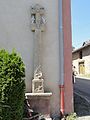
one of the wayside crosses

another wayside cross

decorated village fountain

_croix_de_chemin_A.jpg)
_croix_de_chemin_B.jpg)
_pompe_-_fontaine.jpg)
Individual evidence
- ↑ Source on the name of the community
- ↑ moving sights
- ↑ Memorial to the Fallen
- ↑ Commemorative plaque for the fallen