Athienville
| Athienville | ||
|---|---|---|

|
|
|
| region | Grand Est | |
| Department | Meurthe-et-Moselle | |
| Arrondissement | Luneville | |
| Canton | Baccarat | |
| Community association | Pays du Sânon | |
| Coordinates | 48 ° 43 ' N , 6 ° 29' E | |
| height | 212-335 m | |
| surface | 12.96 km 2 | |
| Residents | 176 (January 1, 2017) | |
| Population density | 14 inhabitants / km 2 | |
| Post Code | 54370 | |
| INSEE code | 54026 | |
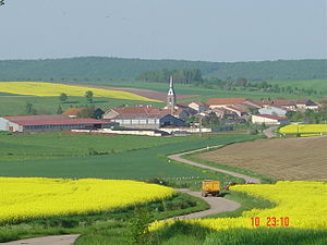
 View of Athienville |
||
Athienville is a French commune with 176 inhabitants (as of January 1, 2017) in the Meurthe-et-Moselle department in the Grand Est region . It belongs to the Arrondissement Lunéville and the municipality association Pays du Sânon .
geography
Athienville is located 230 m above sea level, about 16 kilometers north of the city of Lunéville and about 13 kilometers south of Château-Salins .
The municipality covers a section of the gently undulating area between the Seille and Sânon rivers east of Nancy . The almost 13 km² large community area consists for the most part of agricultural land. About a quarter of the area is forested ( Forêt de Ranzey in the west and Bois de Bénamont in the southeast). One kilometer northeast of the village center, the Jumelles hills (= twins; 293 and 287 m above sea level) form two striking focal points, which are also stylized in the municipality's coat of arms by a red zigzag bar.
Athienville includes the hamlets and farms of Hincourt, Ferme de Harlauville and Ferme de Ranzey .
Neighboring communities of Athienville are Bezange-la-Grande in the north, Arracourt in the east, Bathelémont in the southeast, Valhey in the south, Serres in the southwest and Hoéville in the west.
history
Before the Franco-Prussian War, the municipality belonged to the canton of Vic-sur-Seille . After the Treaty of Frankfurt, the southern part of this canton became the new canton Arracourt, which remained with France and to which Athienville also belonged.
Population development
| year | 1962 | 1968 | 1975 | 1982 | 1990 | 1999 | 2007 | 2016 | |
| Residents | 152 | 185 | 160 | 177 | 182 | 172 | 163 | 178 | |
| Sources: Cassini and INSEE | |||||||||
Attractions
Altar and tabernacle of the Church of St. Peter and Paul ( Église Saint-Pierre et Saint-Paul ) from the first half of the 18th century (repainted and gilded in 1920) are classified as Monument historique .
Economy and Infrastructure
Ten farms are located in the community of Athienville (grain cultivation, dairy farming).
Athienville is away from the major national traffic connections. The trunk road from Lunéville via Moyenvic to Château-Salins runs through the neighboring communities of Arracourt and Valhey . Other roads connect Athienville with the municipalities of Bezange-la-Grande and Serres .
supporting documents
- ↑ Description of the coat of arms on genealogie-lorraine.fr (French)
- ^ Athienville on cassini.ehess.fr
- ↑ Athienville on insee.fr
- ↑ Entry on culture.gouv.fr (French)
- ↑ Farms on annuaire-mairie.fr (French)
