
Veney
| Veney | ||
|---|---|---|

|
|
|
| region | Grand Est | |
| Department | Meurthe-et-Moselle | |
| Arrondissement | Luneville | |
| Canton | Baccarat | |
| Community association | Territoire de Lunéville à Baccarat | |
| Coordinates | 48 ° 28 ' N , 6 ° 49' E | |
| height | 274-346 m | |
| surface | 3.45 km 2 | |
| Residents | 50 (January 1, 2017) | |
| Population density | 14 inhabitants / km 2 | |
| Post Code | 54540 | |
| INSEE code | 54560 | |
_mairie.jpg) Town hall (Mairie) of the municipality |
||

Veney is a French commune with 50 inhabitants (as of January 1, 2017) in the Meurthe-et-Moselle department in the Grand Est region (before 2016 Lorraine ). It belongs to the Arrondissement of Lunéville and the Canton of Baccarat .
geography
The municipality is located about 53 kilometers southeast of Nancy in the southeast of the Meurthe-et-Moselle department. Large parts of the community are forested. Neighboring municipalities are Vacqueville in the northwest, north and northeast, Neufmaisons in the east, Bertrichamps in the south and Merviller in the west.
history
Today's municipality is first mentioned in a document as Venneiz in 1327 . Veney historically belonged to the Vogtei (Bailliage) Vic and thus to the province of Trois-Évêchés (Three Bishoprics), which in fact fell to France in 1552. Until the French Revolution , the community was then in the Grand-gouvernement de Lorraine-et-Barrois . From 1793 to 1801 the municipality was assigned to the Blâmont district and the canton of Badouviller. Since 1801 it has been part of the canton of Baccarat and also assigned to the Arrondissement of Lunéville. Until 1871, the community was in the old Meurt (h) e. Since then it has been part of the Meurthe-et-Moselle department .
Population development
| year | 1793 | 1836 | 1911 | 1921 | 1962 | 1968 | 1975 | 1982 | 1990 | 1999 | 2007 | 2015 |
| Residents | 129 | 243 | 122 | 85 | 47 | 39 | 22nd | 29 | 42 | 42 | 51 | 51 |
| Source: Cassini and INSEE | ||||||||||||
traffic
Veney is close to the railway line from Lunéville to Saint-Dié-des-Vosges. The nearest stops are in the neighboring municipality of Bertrichamps and in Baccarat. Not far from the municipality, the N59 with a full connection leads past Bertrichamps. The D167 / 167a, which runs through the village, is important for regional traffic.
Attractions
- two wayside crosses in the forest (Bois du Basseret) and in the village (on the Rue des Fontaines)
- Memorial stele and plaque for the fallen
- Village fountain
- Lavoir (wash house)
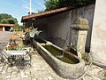
Village fountain

Memorial to a fallen man

Wayside cross on rue des Fontaines

Wayside cross in the forest (Bois du Basseret)

Lavoir of the parish
_fontaine.jpg)
_m%C3%A9morial_de_guerre,_D_167A.jpg)
_croix_de_chemin.jpg)
_croix_de_chemin_en_for%C3%AAt.jpg)
_lavoir.jpg)
Individual evidence
- ↑ Source on the name of the community
- ↑ Memorial stele for the fallen on the road from Veney to Bertrichamps
- ↑ Commemorative plaque for the fallen on the wall of the Mairie