
Fréménil
| Fréménil | ||
|---|---|---|

|
|
|
| region | Grand Est | |
| Department | Meurthe-et-Moselle | |
| Arrondissement | Luneville | |
| Canton | Baccarat | |
| Community association | Vezouze en Piémont | |
| Coordinates | 48 ° 34 ' N , 6 ° 43' E | |
| height | 240-264 m | |
| surface | 3.04 km 2 | |
| Residents | 216 (January 1, 2017) | |
| Population density | 71 inhabitants / km 2 | |
| Post Code | 54450 | |
| INSEE code | 54210 | |
_vue_du_village.jpg) View of the community |
||

Fréménil is a French commune with 216 inhabitants (as of January 1, 2017) in the Meurthe-et-Moselle department in the Grand Est region (before 2016 Lorraine ). It belongs to the Arrondissement of Lunéville and the Canton of Baccarat (until 2015 the Canton of Blâmont ).
geography
The municipality is located about 41 kilometers south-east of Nancy in the south-east of the Meurthe-et-Moselle department on a plain on the Vezouze River . This forms the municipal boundary in parts. Neighboring municipalities are Domjevin in the northwest and north, Blémerey in the northeast, Saint-Martin and Herbéviller in the east, Ogéviller in the southeast and south, Buriville in the southwest and Bénaménil in the west.
history
The present parish is first mentioned in 1034 under the name Fraimonvilla in a document from the Abbey of Saint-Remy. Fréménil was under the Bailiwick of Vic and historically belonged to the province of Trois-Évêchés (Three Bishoprics), which in fact fell to France in 1552. Until the French Revolution , the community was then in the Grand-gouvernement de Lorraine-et-Barrois . There was destruction in the two world wars. From 1793 to 1801 the municipality was assigned to the Blâmont district. From 1793 to 1801 it was part of the canton of Ogeviller (Ogéviller). From 1801 to 2015, the municipality was incorporated into the canton of Blâmont. Since 1801 it has been assigned to the Lunéville arrondissement. Until 1871, the community was in the old Meurt (h) e. Since then it has been part of the Meurthe-et-Moselle department .
Population development
| year | 1793 | 1851 | 1936 | 1946 | 1962 | 1968 | 1975 | 1982 | 1990 | 1999 | 2007 | 2015 |
| Residents | 208 | 298 | 195 | 154 | 120 | 123 | 124 | 120 | 140 | 147 | 171 | 226 |
| Source: Cassini and INSEE | ||||||||||||
traffic
Fréménil is not on any railway line. The nearest stops are several kilometers away in Ménil-Flin on the railway line from Lunéville to Saint-Dié-des-Vosges and in Emberménil on the railway line from Paris to Strasbourg. The N4 passes north of the municipality . The closest connection is in Bénaménil. The D19A, which runs through the village, is important for regional traffic.
Attractions
- Saint-Pierre village church from 1776
- Memorial to the Fallen
- old cross at the cemetery
- crossroads
- house portals worth seeing

Town hall (Mairie) of Fréménil

Saint-Pierre village church

Memorial to the Fallen
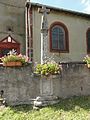
old cross on the village cemetery

crossroads

Detail of a house portal

windmill
_mairie.jpg)
_%C3%A9glise_(01).jpg)
_croix_de_cimeti%C3%A8re,_monument_aux_morts.jpg)
_%C3%A9glise,_croix_ancien_cimeti%C3%A8re.jpg)
_croix_de_chemin.jpg)
_dessus_de_porte_maison.jpg)
_wind_wheel_(01).jpg)