Juvrecourt
| Juvrecourt | ||
|---|---|---|

|
|
|
| region | Grand Est | |
| Department | Meurthe-et-Moselle | |
| Arrondissement | Luneville | |
| Canton | Baccarat | |
| Community association | Pays du Sânon | |
| Coordinates | 48 ° 45 ' N , 6 ° 34' E | |
| height | 221-315 m | |
| surface | 6.11 km 2 | |
| Residents | 58 (January 1, 2017) | |
| Population density | 9 inhabitants / km 2 | |
| Post Code | 54370 | |
| INSEE code | 54285 | |
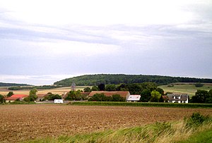
 View of Juvrecourt |
||
Juvrecourt is a French commune with 58 inhabitants (as of January 1, 2017) in the Meurthe-et-Moselle department in the Grand Est region . It belongs to the Arrondissement Lunéville and the municipality association Pays du Sânon .
geography
Juvrecourt is 240 m above sea level, about 20 kilometers north of the city of Lunéville and about 30 kilometers east-northeast of the city of Nancy . In the north, the area of the municipality borders on the Moselle department .
The municipality covers a section of the Loutre Noire valley. The terrain gradually rises north and south of the valley area. In the northwest, the ridge of the Haut des Monts and the large forest area Forêt Domaniale de Bezange-la-Grande lead over to the Seilletal . With the exception of a wooded area in the north ( Bois Saint-Piamont ), the municipal area is characterized by large arable land.
Neighboring communities of Juvrecourt are Moyenvic in the north, Xanrey in the east, Bezange-la-Petite in the south-east (point of contact), Réchicourt-la-Petite in the south, Arracourt in the south-east and Vic-sur-Seille in the north-west.
history
The place name probably comes from the Gallic gabros ( = goat ) with the frequently occurring addition court (Latin curtis for court ). It changed over the centuries from Givricourt (1152) to Geveroucourt (1178), Gievrecourt, Gyevrecourt, Gieuvercourt (1476), Gieuvrecourt (1553) and Givrecourt (1600) to today's Juvrecourt .
The municipality bears the former coat of arms of the Aubertin family , the former lords of Bathelémont and Juvrecourt. A silver cross on a blue background was added to the coat of arms; it refers to the local Church of Exaltation of the Cross .
The village of Juvrecourt was on the border with the German Empire from 1871 to 1914. Before the Franco-Prussian War it belonged to the canton of Vic-sur-Seille . After the Treaty of Frankfurt , the southern part of this canton became the new canton Arracourt, which remained with France and which also includes Juvrecourt.
Population development
| year | 1962 | 1968 | 1975 | 1982 | 1990 | 1999 | 2007 | 2016 | |
| Residents | 73 | 62 | 57 | 49 | 51 | 54 | 67 | 61 | |
| Sources: Cassini and INSEE | |||||||||
Attractions
In the Church of the Exaltation of the Cross ( Église de l'exaltation de la Sainte Croix ) there is a 88 cm high wooden Pietà . This sculpture dates from around 1510 and is attributed to a student of Tilman Riemenschneider . It is classified as a monument historique .
Economy and Infrastructure
Agriculture still plays an important role in Juvrecourt. There are three farms in Juvrecourt (grain cultivation, pig farming)
In the northern neighboring municipality of Moyenvic , the highways from Lunéville , Sarrebourg , Metz and Nancy meet.
supporting documents
- ^ Dictionnaire topographique du département de la Meurthe p 98, Henri Lepage , 1862
- ↑ Origin of the coat of arms on genealogie-lorraine.fr (French, no longer available since 2018)
- ↑ Juvrecourt on cassini.ehess.fr
- ↑ Juvrecourt on insee.fr
- ↑ Entry on www.culture.gouv.fr (French)
- ↑ Farms on annuaire-mairie.fr (French)
