Cleurie
| Cleurie | ||
|---|---|---|

|
|
|
| region | Grand Est | |
| Department | Vosges | |
| Arrondissement | Saint-Dié-des-Vosges | |
| Canton | Remiremont | |
| Community association | Hautes Vosges | |
| Coordinates | 48 ° 3 ' N , 6 ° 41' E | |
| height | 416-819 m | |
| surface | 11.04 km 2 | |
| Residents | 651 (January 1, 2017) | |
| Population density | 59 inhabitants / km 2 | |
| Post Code | 88120 | |
| INSEE code | 88109 | |
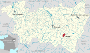
 Location of the municipality of Cleurie in the Vosges department |
||
Cleurie is a French commune with 651 inhabitants (as of January 1, 2017) in the Vosges department of the Grand Est region (until 2015 Lorraine ). It belongs to the Arrondissement of Saint-Dié-des-Vosges and the Hautes Vosges municipal association .
geography
The municipality of Cleurie is located in the Vosges between the towns of Remiremont and Gérardmer .
The 11 km² large municipality of Cleurie is bordered in the southeast by the river Cleurie , which was the inspiration for the municipality name. The approximately 200 meter wide valley lies at 420 to 460 meters above sea level. The mountain streams Ruisseau des Basses, Le Grand Rupt and Ruisseau des Voues flow into the Cleurie in the municipality. The terrain rises to the northwest to 750 to 800 meters, in the north of the municipality the highest point is reached at the Tête de la Charmotte at 819 meters.
The higher elevations in the north and west of the municipality are forested and belong to the Forêt Domaniale de Fossard . Cleurie is a typical scattered settlement in the Lorraine part of the Vosges. No village center has emerged, the single house development on exposed south-facing slopes has recently increased. The bank of the Cleurie, on the other hand, is hardly built on. The districts Flaconnière in the northeast and Putière in the southwest belong to the municipality . Due to the altitude, arable farming takes place only to a modest extent, pastureland, on the other hand, can be found up to the higher slopes.
Neighboring municipalities of Cleurie are Tendon in the north, Le Tholy in the northeast, La Forge in the east, Le Syndicat in the southeast, Saint-Amé in the south and Saint-Étienne-lès-Remiremont in the west.
history
The area of today's parishes of Cleurie and La Forge was in Ban Moulin , which was dependent on the provost in Arches . After the construction of the churches in Le Tholy and Saint-Amé , the residents were parish in the churches closer to each other. In the time of the new congregations being formed during the French Revolution, the old ban and parish boundaries were no longer taken into account. Two communities emerged from the old mill spell. The place name Les Arrentès de Cleurie became Cleurie , and Les Arrentés du Ban de Saint-Joseph became the municipality of La Forge.
In 1850 the Mairie-école (town hall school) was built. It was destroyed in 1944 after shell fire, and it was rebuilt in 1954.
For the year 1936 there is more precise statistical information that a teacher couple collected. At that time there were 378 residents in the community, eight of them were foreigners. The population was 86 households in 70 houses. Three houses were uninhabited. It is also mentioned that in the period between 1911 and 1936 there was a tendency to move into the valley from the higher elevations.
Between the two world wars, the Cleurie community achieved a certain level of prosperity through agriculture, handicrafts and a granite quarry. Even then, many residents commuted to the neighboring community of Le Syndicat . There were two weaving mills and a cardboard factory here.
Population development
| year | 1962 | 1968 | 1975 | 1982 | 1990 | 1999 | 2007 | 2017 | |
| Residents | 413 | 390 | 445 | 625 | 668 | 669 | 622 | 651 | |
| Sources: Cassini and INSEE | |||||||||
From the 1970s the municipality of Cleurie experienced an upswing with an increase in population, which was due to redevelopment measures and increased designation of building areas.
Economy and Infrastructure
Only a few residents of the community still make a living from agriculture. Eight farms are still based in Cleutie (dairy farming, cattle breeding, sheep and goat farming, fruit growing). The ZA du Champ de l'Etraye is a small business park in the south of the municipality . The electronics company Enrulec works here with around 60 employees. In addition to a traditional small sawmill, there is another medium-sized company in Cleurie, the Impression Rotative Cod'Etiq . He specializes in the production of barcodes and labels. Most working people, however, commute to the industrial and service companies in the immediate vicinity.
Today Cleurie is also active in the tourist area through holiday homes. The municipality owes this development to its location near the waterfalls of Tendon and the Lac de Gérardmer as well as its convenient transport links.
The community is the location of a primary school.
There are no churches in Cleurie. The nearby churches in Saint-Amé and in the Julienrupt district of the Le Syndicat community are responsible for pastoral care .
In the Cleurietal, the departmental road 417 runs from Remiremont via Gérardmer to Colmar . There are also road connections to the neighboring communities of La Forge and Saint-Amé . There is a road connection to Éloyes in the Moselle valley that cannot be used all year round via the 730 meters high Col du Singe .

