
Lubine
| Lubine | ||
|---|---|---|

|
|
|
| region | Grand Est | |
| Department | Vosges | |
| Arrondissement | Saint-Dié-des-Vosges | |
| Canton | Saint-Dié-des-Vosges-2 | |
| Community association | Saint-Dié-des-Vosges | |
| Coordinates | 48 ° 19 ′ N , 7 ° 9 ′ E | |
| height | 448-851 m | |
| surface | 14.85 km 2 | |
| Residents | 228 (January 1, 2017) | |
| Population density | 15 inhabitants / km 2 | |
| Post Code | 88490 | |
| INSEE code | 88275 | |
 Location of Lubine in the Vosges department |
||

Lubine (1539: Loubingen ) is a French commune with 228 inhabitants (as of January 1, 2017) in the Vosges department in the Grand Est region (until 2015 Lorraine ). It belongs to the arrondissement of Saint-Dié-des-Vosges and the canton of Saint-Dié-des-Vosges-2 .
geography
Lubine is the easternmost municipality in the Vosges department. It is located on the upper reaches of the Fave River at an altitude between 448 and 851 m above sea level. The municipality covers 14.85 km². Lubine is the western valley station of the 602 m high Col d'Urbeis , which leads into the neighboring Alsace region (municipality of Urbeis ). The municipality is part of the Ballons des Vosges Regional Nature Park .
Population development
| year | 1962 | 1968 | 1975 | 1982 | 1990 | 1999 | 2007 |
| Residents | 216 | 264 | 216 | 187 | 221 | 214 | 242 |
Economy and Infrastructure
The D23 departmental road and the Strasbourg - Saint-Dié-des-Vosges railway , which is operated by the French local transport company TER Alsace (Colroy-Lubine station in Colroy-la-Grande ), serve through traffic .
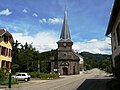
Eglise de la Pentecôte from the 18th century
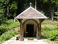
Chapelle de la Jambe-de-Fer from the 18th century

Memorial to those who fell in the world wars


