
Granges-Aumontzey
| Granges-Aumontzey | ||
|---|---|---|
.svg)
|
|
|
| region | Grand Est | |
| Department | Vosges | |
| Arrondissement | Saint-Dié-des-Vosges | |
| Canton | Gerardmer | |
| Community association | Hautes Vosges | |
| Coordinates | 48 ° 9 ' N , 6 ° 47' E | |
| height | 454-922 m | |
| surface | 33.01 km 2 | |
| Residents | 2,665 (January 1, 2017) | |
| Population density | 81 inhabitants / km 2 | |
| Post Code | 88640 | |
| INSEE code | 88218 | |
 Hôtel de ville (Town Hall) of Granges-Aumontzey |
||

Granges-Aumontzey is a French commune with 2,700 inhabitants in the Vosges department of the Grand Est region . It belongs to the arrondissement of Saint-Dié-des-Vosges and to the Hautes Vosges community association founded in 2017 .
The municipality was created with effect from January 1, 2016 through the merger of the former municipalities of Granges-sur-Vologne and Aumontzey to form a Commune nouvelle .
structure
| District | former INSEE code |
Area (km²) |
Altitude (m) |
Population (2016) |
|---|---|---|---|---|
| Aumontzey | 88018 | 3.37 | 454-732 | 494 |
| Granges-sur-Vologne (administrative headquarters) | 88218 | 29.64 | 473-922 | 2,206 |
geography
The municipality of Granges-Aumontzey is located in the Vosges , about 27 kilometers east of Épinal and twelve kilometers northwest of Gérardmer .
The 33 km² municipal area extends partly in the Ballons des Vosges Regional Nature Park over twelve kilometers along the upper reaches of the Vologne River . The Vologne has cut deeply into the surrounding mountains. Only in the area of the village of Granges does the valley ( Vallée des Granges ) expand to about 1000 m width. To the east and west of the Volognetal valley, the wooded mountain peaks reach heights of over 700 m above sea level. The highest point at 926 m is located in the extreme southeast of the municipality.
More than half of the municipality is covered by forests. It is a large contiguous forest, Forêt Domaniale de Vologne . The altitude of the valley locations of over 600 meters means that there is hardly any economic arable farming, so cattle pastures dominate in the valley and on the lower slopes. There are also individual mountain farms in the higher elevations.
In addition to the small town of Granges-sur-Vologne and the village of Aumontzey, Granges-Aumontzey includes the districts of Frambéménil, Les Voids, Chevalpré, Les Jumeaix, Le Hulle, La Sauteure, Blanchefeigne, Les Évelines, Les Aulnaux, Petempré, Le Haut Rain, Le Spoix and Berchigranges .
Neighboring municipalities of Granges-Aumontzey are La Chapelle-devant-Bruyères in the north and northeast, Barbey-Seroux in the east, Gérardmer in the southeast, Liézey in the south, Champdray in the west and Jussarupt and Laveline-devant-Bruyères in the northwest.
history
Granges
The spell Granges was before the revolution of the Bailliage of Bruyeres . The village church, dedicated to St. George, was a branch of the parish in Champ-le-Duc . After the formation of the southern Lorraine communities in 1790, Granges was the canton's capital from 1792 to 1801. In May 1836 Granges had to give up a small part of its territory along with other municipalities to create the new municipality of Liézey . The municipality has been using the additional designation -sur-Vologne since a corresponding ordinance of July 24, 1917 to differentiate itself from other municipalities called Granges .
Aumontzey
Aumontzey was first mentioned in writing in 1393 as Amonzei . The village also belonged to the Bailliage of Bruyères, but ecclesiastically to the parish in neighboring Jussarupt.
coat of arms
The coat of arms of the former municipality of Granges-sur-Vologne shows the patron saint St. George as a dragon slayer on a blue background in silver ; in the right upper corner on a silver background a red water wheel, which refers to the numerous mills on the Vologne . The former municipality of Aumontzey did not have a coat of arms.
Population development
| local community | Population (Census) | ||||||||||
|---|---|---|---|---|---|---|---|---|---|---|---|
| 1962 | 1968 | 1975 | 1982 | 1990 | 1999 | 2006 | 2008 | 2011 | 2013 | 2016 | |
| Aumontzey | 469 | 459 | 505 | 450 | 436 | 442 | 466 | 473 | 498 | 481 | 494 |
| Granges-sur-Vologne | 2880 | 2753 | 2794 | 2758 | 2485 | 2449 | 2332 | 2298 | 2284 | 2251 | 2206 |
| Granges-Aumontzey | 3,349 | 3,212 | 3,299 | 3,208 | 2,921 | 2,891 | 2,798 | 2,771 | 2,782 | 2,732 | 2,700 |
| Sources: Cassini and INSEE | |||||||||||
The (total) population of the municipality of Granges-sur-Vologne was determined by adding up the municipalities that were independent until the end of 2015.
Attractions
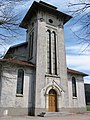
- Saint-Georges church in Granges from the 15th century (the tower dates from 1662) with a Jacquot organ
- Notre-Dame-du-Saint-Rosaire chapel in Aumontzey
- privately operated botanical garden in the Berchigranges district
- several field crosses in the area of the municipality
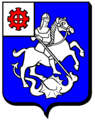
Granges-sur-Vologne coat of arms

Saint-Georges church in Granges
Notre-Dame-du-Saint-Rosaire chapel in Aumontzey

former town hall of Aumontzey, used as a school

Part of the Berchigranges Botanical Garden


.JPG)
Economy and Infrastructure


The residents of Granges-Aumontzey are employed in the forestry and timber industry (several sawmills) or in the trade and services sector. There are also jobs in the tourism sector (boarding houses and holiday homes). There are 24 farms in the community (cereal, potato and fruit growing, dairy farming, camel breeding (!), Horses, sheep and goats). The largest employer in the community is the textile company "Walter-Seitz". Until the middle of the 19th century, hemp was processed at home on handlooms in winter in the Vosges. In Granges and the surrounding area, they specialized in the manufacture of household linen. Cotton spinning began in Granges-sur-Vologne in 1856 with the entrepreneur Étienne Joseph Seitz , who used the water power of the Vologne for mechanization. Unlike in many areas of Lorraine, which saw the decline of the textile industry in the second half of the 20th century, the textile company in Granges-sur-Vologne has survived to this day.
Granges-sur-Vologne is on Départementsstrasse 423, which connects Bruyères with Gérardmer . There are also road connections to Le Tholy , Laval-sur-Vologne , Herpelmont and Corcieux . The nearest train station is in the municipality of Laveline-devant-Bruyères, six kilometers away . From 1878 to 1988 Granges and Aumontzey had stations on the railway line from Laveline-devant-Bruyères to Gérardmer, which branched off from the Arches - Saint-´Dié line. A restart of the railway line to Gérardmer is being discussed.
Parish partnership
A partnership has existed between Granges-sur-Vologne and the Württemberg community of Ertingen since 1990 .
Web links
Individual evidence
- ↑ Population figures retrospectively from January 1, 2016
- ↑ ( Page no longer available , search in web archives: Granges-sur-Vologne on vosges-archives.com ) (PDF file, French)
- ↑ ( Page no longer available , search in web archives: Aumontzey on vosges-archives.com ) (PDF file, French)
- ↑ ( page no longer available , search in web archives: coat of arms description on genealogie-lorraine.fr ) (French)
- ↑ Granges-sur-Vologne on cassini.ehess.fr
- ↑ Aumontzey on cassini.ehess.fr
- ↑ Granges-Aumontzey on insee.fr
- ↑ Farms on annuaire-mairie.fr (French)
- ↑ Tradition of the textile industry since 1856 (French)
- ↑ Analysis of the recommissioning of the Laveline-Gérardmer railway line (PDF file, French)