
Basse-sur-le-Rupt
| Basse-sur-le-Rupt | ||
|---|---|---|

|
|
|
| region | Grand Est | |
| Department | Vosges | |
| Arrondissement | Saint-Dié-des-Vosges | |
| Canton | La Bresse | |
| Community association | Hautes Vosges | |
| Coordinates | 47 ° 59 ′ N , 6 ° 46 ′ E | |
| height | 409–1,060 m | |
| surface | 13.73 km 2 | |
| Residents | 864 (January 1, 2017) | |
| Population density | 63 inhabitants / km 2 | |
| Post Code | 88120 | |
| INSEE code | 88037 | |
 Mairie in the district of Planois |
||

Basse-sur-le-Rupt is a French commune in the Vosges department in the region of Grand Est (2015 Lorraine ). It belongs to the Arrondissement of Saint-Dié-des-Vosges and the Hautes Vosges municipal association . Since a resolution in 2000, the residents of the community have been calling themselves Bassuroises .
geography

The municipality of Basse-sur-le-Rupt is located in the Vosges , 15 kilometers east of the town of Remiremont .
The 13.73 km² municipal area of Basse-sur-le-Rupt extends over the high valley of the eponymous mountain river Rupt , which opens to the west to the Moselotte and is bordered to the north, east and south by mountain ridges, some of which are over 900 meters high to reach. The settlement area consists of the districts Pubas, Contrexard, Trougemont and Planois as well as the hamlets of La Burotte, Presles and L'Echté , whereby Planois with the church and the seat of the mayor has developed into the capital of the municipality. About a third of the municipal area consists of forests ( Forêt de Noire Goutte in the south). In the northeast of the municipality the highest point is reached at Calotte du Ronfaing at 1060 meters above sea level, in the west on the right bank of the Moselotte is the lowest point at 409 meters above sea level.
For climatic reasons, there are only small arable land in the lower valley regions; instead, meadows and pastures dominate up to an altitude of 700 meters above sea level.
Neighboring municipalities of Basse-sur-le-Rupt are Gerbamont in the north, Rochesson and La Bresse in the northeast, Cornimont in the east, Saulxures-sur-Moselotte and Tendon in the south and Vagney in the west.
history
The high valley of the Rupt was probably settled from the 14th century. The area of Basse-sur-le-Rupt was part of the extensive Ban de Vagney , which also included the now independent municipalities of Vagney , Sapois , Gerbamont , Saint-Amé and Saulxures . The Ban de Vagney was half subordinate to the Dukes of Lorraine and half to the Chapter of Remiremont .
According to documents, a mill on the Rupt appeared as early as 1304, which was also mentioned several times in the following centuries.
Today's district of Contrexard (1425 Contraxair ) was, like Pubas , part of a community called Syndicat sur le Rupt before the French Revolution . In the 18th century many pavers and bridge builders lived here. Planois was first mentioned in 1345 as Jéhan de Plainnoy , the district of Trougemont in 1669 as Trugimont .
The present municipality was established in 1790. From 1793 to 1809 it was called Basse la Montagne . Until the construction of the Saint-Nicolas church, the residents of neighboring Vagney were parish. The first café in town was built at the same time as the church. In 1793 the spelling of the place name was La Basse sur le Rupt , in 1801 Basse-sur-le-Rapt .
The abundance of water and the gradient were good prerequisites for operating water mills in the Rupt area. Four mills have been handed down for the year 1790. Another was built in Planois in 1819. The mills were the starting point for industrialization, which began in Trougemont in 1853 with the construction of a weaving mill. More than two hundred workers were employed here in the 1880s. The history of the textile industry ended in 1973 with the closure of the company. A 30 meter high granite chimney still reminds of the plant today.
Granite mining and its processing, especially into tombstones, also has a long tradition in Basse-sur-le-Rupt.
Population development
After the textile factories closed in the mid-1970s, many residents left the community. Due to the scenic location and favorable land prices, the population of Basse-sur-le-Rupt rose again from the 1980s.
| year | 1962 | 1968 | 1975 | 1982 | 1990 | 1999 | 2006 | 2017 | |
|---|---|---|---|---|---|---|---|---|---|
| Residents | 718 | 778 | 704 | 786 | 804 | 819 | 881 | 864 | |
| Sources: Cassini and INSEE | |||||||||
Attractions

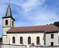
- Saint-Nicolas Church, built in 1848
- Le Haut du Roc viewpoint in the south of the municipality at 1014 meters above sea level
- La Pierre des Quatre Communes , with 1060 meters the highest point in Basse-sur-le-Rupt, at the same time the border marking of four communities that meet here (in addition to Basse-sur-le-Rupt also Cornimont, Rochesson and La Bresse)
- La Croix des Moinats , memorial in memory of the Moroccan allies in World War II
- Piquante-Pierre , memorial stone for the fallen in World War II
- Saint-Nicolas church


Economy and Infrastructure
In Basse-sur-le-Rupt there is a granite processing company and a sawmill, as well as smaller craft businesses. There are 16 farms in the community (vegetable growing, dairy farming, cattle, sheep, goat and poultry farming). In recent years the tourist offers in Basse-sur-le-Rupt have been expanded. This is how many individual holiday homes were created. Some of the residents commute to the nearby industrial locations.
There is a primary school in the Planois district and a kindergarten in Trougemont.
The road from Vagney to La Bresse runs through Basse-sur-le-Rupt . It follows the Rupttal over the saddle of the Col de la Croix des Moinats (890 m) into the upper Moselotte valley . There are road connections to the southern and northern neighboring towns via the passes Col du Haut de Fouchure (790 m), Col de Menufosse (975 m), Col des Hayes (885 m) and Col de la Burotte (795 m).
supporting documents
- ↑ toponym on cassini.ehess.fr
- ↑ Basse-sur-le-Rupt on cassini.ehess.fr
- ↑ Basse-sur-le-Rupt on insee.fr
- ↑ Farms on annuaire-mairie.fr (French)
Web links
- Population statistics
- Congregation presentation ( Memento from January 15, 2008 in the Internet Archive ) (French)
- Information from the Tourist Office ( Memento of February 17, 2015 in the Internet Archive ) (French)