Barbey-Seroux
| Barbey-Seroux | ||
|---|---|---|
|
|
||
| region | Grand Est | |
| Department | Vosges | |
| Arrondissement | Saint-Dié-des-Vosges | |
| Canton | Gerardmer | |
| Community association | Saint-Dié-des-Vosges | |
| Coordinates | 48 ° 9 ′ N , 6 ° 50 ′ E | |
| height | 545-870 m | |
| surface | 7.32 km 2 | |
| Residents | 148 (January 1, 2017) | |
| Population density | 20 inhabitants / km 2 | |
| Post Code | 88640 | |
| INSEE code | 88035 | |
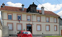
 View of Barbey-Seroux |
||
Barbey-Seroux is a French commune in the Vosges department in the region of Grand Est (before 2016 Lorraine ). It belongs to the arrondissement of Saint-Dié-des-Vosges and to the municipal association of Saint-Dié-des-Vosges, founded in 2017 .
geography
The community of Barbey-Seroux with 148 inhabitants (January 1, 2017) is located about ten kilometers north of the town of Gérardmer in the Vosges . The municipal area extends east of the Vologne in the catchment area of its right tributary Corbeline . The south-western boundary of the municipality follows the edge of the edge of the 200-meter-deep Vologne valley for more than eight kilometers.
Barbey-Seroux is not a grown village, there is no distinctive settlement core. The parish, consisting of the former places Barbey and Seroux , is made up of the following scattered hamlets and farms:
|
|
Almost the entire 7.32 km² community area is forested ( Forêt Domaniale de Vologne, Bois des Pschés ); Agriculturally usable areas can only be found in the north of the municipality or on smaller clearing islands. The highest peaks are in the south of the municipality:
|
The highest point in the municipality with 870 m is an unnamed elevation in the extreme southern tip. The mountain streams that arise in the municipality of Barbey-Seroux flow over the Corbeline to the Vologne , which drains west to the Moselle . Barbey-Seroux is part of the Ballons des Vosges Regional Nature Park .
Neighboring municipalities of Barbey-Seroux are Vienville in the north, Arrentès-de-Corcieux in the northeast and east, Gerbépal in the east, Gérardmer in the south and Granges-sur-Vologne in the southwest and west.
history

The place name Seroux first appeared in a document in 1457. The former manor house was owned by the Dukes of Lorraine and the Barbas family . The place name Barbey probably originated from the name of these knights . From 1710 the area of what is now Barbey-Seroux came under the influence of the Bruyères Bailiwick , from 1751 it belonged to the dominion of Saint-Dié . In 1793, during the French Revolution, the municipality of Barbey-Seroux was formed, which was assigned to the district of Bruyeres and the canton of Granges, which no longer exists today. Ecclesiastically, Barbey-Seroux was an annex to the parish of Granges-sur-Vologne in the deanery Épinal of the diocese of Toul . Until the middle of the 20th century, mainly rye, oats, potatoes and flax were grown on small cleared islands, but hemp, hay and oil were also produced. A flour mill and a communal oven were located in the hamlet of Béninfaing . Until the end of the 19th century, many Belgians worked in the granite quarries near the district of Les Tronces , mainly producing paving stones.
Population development
| year | 1962 | 1968 | 1975 | 1982 | 1990 | 1999 | 2006 | 2017 | |
| Residents | 138 | 121 | 109 | 111 | 115 | 116 | 131 | 148 | |
| Sources: Cassini and INSEE | |||||||||
Attractions
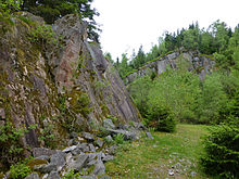
There are no churches or chapels in Barbey-Seroux, just a wayside cross near the town hall. A tourist attraction for hikers is the stone field ( Champ de Roches ) in a forest clearing in the east of the municipality. The origin and arrangement of the stones on an area of 400 × 40 m has not yet been finally clarified because the ground marks for the glacier theory absence.
Economy and Infrastructure
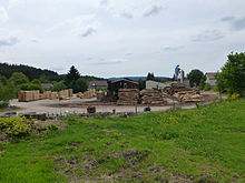
Forestry and wood processing are traditionally represented in the community (sawmill). The granite quarries in the south of the municipality are no longer in operation today. The very small arable and pasture areas are used for self-sufficiency. In addition, tourism (holiday homes) is also playing an increasing role.
The municipality of Barbey-Seroux is located off the nationally important traffic routes. The year-round road from Corcieux to Granges-sur-Vologne (D 31) runs through the municipality . Another road connection leads to Arrentès-de-Corcieux . There is a rail connection in La Houssière , ten kilometers away ( Arches - Saint-Dié line ).
supporting documents
- ↑ Barbey-Seroux on vosges-archives.com. (PDF; 78 kB) (No longer available online.) Archived from the original on March 4, 2016 ; Retrieved October 8, 2015 (French). Info: The archive link was inserted automatically and has not yet been checked. Please check the original and archive link according to the instructions and then remove this notice.
- ^ Villes et villages du département des Vosges , Henri Lepage, 1845
- ↑ Barbey-Seroux on cassini.ehess.fr
- ↑ Barbey-Seroux on insee.fr
- ↑ La Lorraine sorcière. Histoire, legends et croyances , Roger Maudhuy, 2010
- ↑ Forestry operations on annuaire-mairie.fr (French)


