
Saint-Léonard (Vosges)
| Saint-Léonard | ||
|---|---|---|
|
||
| region | Grand Est | |
| Department | Vosges | |
| Arrondissement | Saint-Dié-des-Vosges | |
| Canton | Saint-Dié-des-Vosges-2 | |
| Community association | Saint-Dié-des-Vosges | |
| Coordinates | 48 ° 13 ' N , 6 ° 57' E | |
| height | 397-691 m | |
| surface | 14.57 km 2 | |
| Residents | 1,355 (January 1, 2017) | |
| Population density | 93 inhabitants / km 2 | |
| Post Code | 88690 | |
| INSEE code | 88423 | |
| Website | http://www.ville-saintleonard.fr/ | |

Saint-Léonard is a French commune with 1,355 inhabitants (as of January 1, 2017) in the Vosges department in the Grand Est region . It belongs to the Saint-Dié-des-Vosges and the canton of Saint-Dié-des-Vosges-2 . The residents call themselves Léonardiens / Léonardiennes
geography
Saint-Léonard is located around 8 km (as the crow flies) south of Saint-Dié-des-Vosges in the east of the Vosges department. Numerous streams and many wooded hills are typical of the community. The place Saint-Léonard itself lies in the valley floor on the Meurthe . The municipality is part of the Ballons des Vosges Regional Nature Park .
The municipality consists of the village of Saint-Léonard, the hamlets (hameaux) Contramoulin, Girompaire, La Belle Goutte, Le Poteau and Le Pré Chapy and individual farms. Saint-Léonard is surrounded by the neighboring communities of Saulcy-sur-Meurthe in the north, Entre-deux-Eaux in the north-east, Mandray in the east, Anould in the south, La Houssière in the south-west and Taintrux in the north-west.
history
In the 7th century monks settled here. Various feudal lords administered the community in the Middle Ages on behalf of the Dukes of Lorraine and, from 1766, of the Kingdom of France. The place was first mentioned by name as Saint Lyenart in 1303 , the hamlet of Sarupt as Sarrui as early as 1298. The Thirty Years War brought devastation, famine and the plague. This led to a severe population decline. From 1793 to 1801, Saint-Léonard was part of the Saint-Dié district . From 1793 to 1801 the municipality was the canton capital of the canton of Saint Leonard . Thereafter the place belonged to the canton Fraize until 2015 . Administratively, Saint-Léonard was also part of the Arrondissement of Saint-Dié-des-Vosges since 1801 . In early November 1944, the German Wehrmacht destroyed the train station and the water reservoir. All cars, bicycles and food were requisitioned. All men between 16 and 49 years of age were deported eastwards towards the German Reich. On November 10, German soldiers set fire to the entire village and destroyed the remains with dynamite. The village no longer existed. On November 22nd, the remains of the village were liberated by Allied troops.
Population development
| year | 1793 | 1800 | 1846 | 1851 | 1866 | 1876 | 1911 | 1921 | 1946 | 1962 | 1968 | 1975 | 1982 | 1990 | 1999 | 2006 | 2012 |
| Residents | 589 | 496 | 1,047 | 951 | 1,020 | 1,290 | 1,239 | 1,042 | 561 | 990 | 1,036 | 1,190 | 1,220 | 1,210 | 1,220 | 1,358 | 1,358 |
| Sources: Cassini and INSEE | |||||||||||||||||
The increase between 1866 and 1876 is due to immigrants from the realm of Alsace-Lorraine. The high number of casualties in World War I and the flu wave of 1918 led to a sharp population decline between 1911 and 1921. The low population figure of 1946 is due to the destruction of the village by the Wehrmacht in 1944.
Attractions
- Village church of Saint-Pierre-et-Saint-Léonard from the year
- Chapel of Our Lady of Montégoutte from the year 1828
- several old houses and farms
- Monuments to the Fallen

Town hall (Mairie) of Saint-Léonard

Saint-Léonard village center
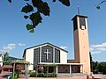
Saint-Pierre-et-Saint-Léonard village church

Farmhouse in typical regional construction

Montégoutte Forest Chapel

Pond in Saint-Léonard
_mairie.jpg)
_place_1.jpg)
_%C3%A9glise.jpg)
,_former_traditional_farmhouse_in_Rue_de_l%E2%80%99%C3%89glise.jpg)
.jpg)
.jpg)
Individual evidence
- ↑ List of the cultural assets of Saint-Léonard (French)
- ↑ Memorial to those who fell in the First World War
- ↑ Memorial stone for two fallen US soldiers in World War II