La Voivre (Vosges)
| La Voivre | ||
|---|---|---|
|
|
||
| region | Grand Est | |
| Department | Vosges | |
| Arrondissement | Saint-Dié-des-Vosges | |
| Canton | Saint-Dié-des-Vosges-1 | |
| Community association | Saint-Dié-des-Vosges | |
| Coordinates | 48 ° 20 ' N , 6 ° 54' E | |
| height | 300-380 m | |
| surface | 5.86 km 2 | |
| Residents | 686 (January 1, 2017) | |
| Population density | 117 inhabitants / km 2 | |
| Post Code | 88470 | |
| INSEE code | 88519 | |
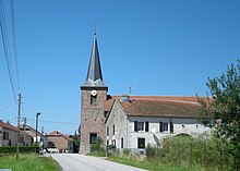
 View of La Voivre |
||
La Voivre is a French commune with 686 inhabitants (as of January 1, 2017) in the Vosges department in the Grand Est region (until 2015 Lorraine ). It belongs to the arrondissement of Saint-Dié-des-Vosges and the canton of Saint-Dié-des-Vosges-1 (until 2015: canton of Saint-Dié-des-Vosges-Ouest ). The inhabitants are called Veprien (ne) s .
geography
La Voivre is located in the Vosges on the Meurthe River , into which the Hure tributary flows. Neighboring municipalities of La Voivre are Étival-Clairefontaine in the north and north-west, Moyenmoutier in the north and north-east, Hurbache in the east, Saint-Dié-des-Vosges in the south and south-east, Saint-Michel-sur-Meurthe in the south and south-west and Nompatelize in the west .
The National Route 59 runs through the municipality .
Population development
| year | 1962 | 1968 | 1975 | 1982 | 1990 | 1999 | 2006 | 2012 |
| Residents | 440 | 466 | 580 | 668 | 662 | 627 | 737 | 714 |
Attractions
- Notre-Dame de l'Assomption church
- Calvaire
Personalities
- Jean-Baptiste Grosgeorge (1846–1902), priest, Vicar Apostolic in Cambodia

