La Croix-aux-Mines
| La Croix-aux-Mines | ||
|---|---|---|

|
|
|
| region | Grand Est | |
| Department | Vosges | |
| Arrondissement | Saint-Dié-des-Vosges | |
| Canton | Saint-Dié-des-Vosges-2 | |
| Community association | Saint-Dié-des-Vosges | |
| Coordinates | 48 ° 13 ' N , 7 ° 3' E | |
| height | 468-1,131 m | |
| surface | 16.8 km 2 | |
| Residents | 503 (January 1, 2017) | |
| Population density | 30 inhabitants / km 2 | |
| Post Code | 88520 | |
| INSEE code | 88120 | |
 Town hall and school building |
||
La Croix-aux-Mines is a French commune with 503 inhabitants (as of January 1, 2017) in the Vosges department in the Grand Est region . It belongs to the Arrondissement of Saint-Dié-des-Vosges and the municipality of Saint-Dié-des-Vosges .
geography
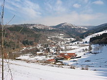
The municipality of La Croix-aux-Mines is located in the Vosges , in the Morte Valley . It is about 15 kilometers from Saint-Dié-des-Vosges , the capital (chef-lieu) of the arrondissement of the same name. The eastern municipal boundary runs on the Vosges ridge and forms the border with the Haut-Rhin department . The Morte flows through the municipal area from the source at the 1005 m high Col du Pré de Raves in the southeast to the west and takes in several small mountain streams, including the Ruisseau de Scarupt , whose five-kilometer-long valley occupies the east of the municipality. The highest point in the municipality of La Croix-aux-Mines is the 1128 m high Rossberg ( le Rossberg ) on the border with Alsace. The "local mountain" of the municipality is the 734 m high Tête de la Behouille, west of La Croix .
The territory of the municipality of La Croix-aux-Mines is part of the Ballons des Vosges Regional Nature Park ( Parc Naturel Régional des Ballons des Vosges ).
Almost three quarters of the 16.8 km² large municipality of La Croix-aux-Mines consists of forests ( Forêt Domaniale de la Croix-aux-Mines ), which extend to the ridge of the Vosges. In the lower-lying areas there is pastureland, and economic arable farming is only possible to a limited extent due to the altitude.
The district and winter sports location Le Chipal belongs to La Croix-aux-Mines .
Neighboring municipalities of La Croix-aux-Mines are Ban-de-Laveline in the north, Sainte-Marie-aux-Mines and Le Bonhomme in the east, Fraize in the south, Mandray in the west and Entre-deux-Eaux and Coinches in the northwest.
history
The name La Croix (The Cross) is documented for the year 1471, the suffix -aux-Mines has been in use since 1611. Since the arrival of Deodatus , Bishop of Nevers , and other hermits in the upper Meurthetal, numerous wayside crosses have been erected. The village of La Croix was probably built on one of these crosses.
There is evidence of mining in the place from the 10th century. At first, silver, copper and mercury mines were established and operated by the nearby monasteries in Moyenmoutier and Saint-Dié . The three most important mines were called Saint-Nicolas, Saint-Jean and Chipal . By 1670 resources were exhausted and mining gradually ceased.
La Croix grew during the mining period and extended north into the area of the Bannes of Laveline , which was part of the Bailiwick of Saint-Die. The village church of St. Nikolaus ( Église Saint-Nicolas ), built in the 18th century, was initially an annex to the Church of the Assumption in Laveline.
Population development
In the middle of the 19th century, La Croix had more than 1500 residents. After three wars and the decline of the textile industry in the area, the population fell below 800.
| year | 1962 | 1968 | 1975 | 1982 | 1990 | 1999 | 2010 | 2017 | |
| Residents | 726 | 696 | 738 | 591 | 569 | 575 | 547 | 503 | |
| Sources: Cassini and INSEE | |||||||||
Attractions
- Saint-Nicolas church, built in the 18th century
- Saint-Marc chapel in the district of Le Chipal from 1762, Monument historique
- Hiking trail to the history of mining with numerous display boards, the u. a. connects former tunnel entrances
Economy and Infrastructure
Agriculture today only plays a subordinate role in the upper Meurthetal. Twelve farms are located in the community (growing of grain, potatoes and vegetables, beekeeping, dairy farming, breeding of cattle, sheep and goats). The cheese production and the distilling of fruit schnapps ( eau de vie ) are noteworthy . Due to the abundance of forests in the upper Vosges, forestry has a long tradition. Numerous holiday homes and guest houses underline the growing importance of tourism in La Croix-aux-Mines.
La Croix is on the D23 trunk road from Fraize to Raves , which forms a link between the Vosges passes Col du Bonhomme and Col de Sainte-Marie . In the municipality of La Croix-aux-Mines is the 1005 m high Col du Pré de Raves , which leads over the Vosges ridge into the Alsatian valleys of Lièpvrette and Fecht . This pass is very popular with cyclists and motorcyclists; the section is considered to be the northern continuation of the Route des Crêtes .
supporting documents
- ^ History on www.vosges-archives.com. (pdf) (No longer available online.) Formerly in the original ; Retrieved April 23, 2014 (French). ( Page no longer available , search in web archives ) Info: The link was automatically marked as defective. Please check the link according to the instructions and then remove this notice.
- ↑ La Croix-aux-Mines on cassini.ehess.fr
- ↑ La Croix-aux-Mines on insee.fr
- ↑ Entry no.PA00125543 in the Base Mérimée of the French Ministry of Culture (French), accessed on April 23, 2014
- ↑ Farms on annuaire-mairie.fr (French)


