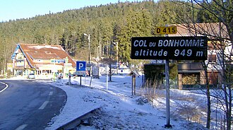
Col du Bonhomme
| Col du Bonhomme | |||
|---|---|---|---|
|
Pass height |
|||
| Compass direction | west | east | |
| Pass height | 949 m | ||
| Department | Vosges | Haut-Rhin | |
| Valley locations | Plainfaing | Le Bonhomme | |
| expansion | D 415 | ||
| Mountains | Vosges | ||
| Map (Haut-Rhin) | |||
|
|
|||
| Coordinates | 48 ° 9 '54 " N , 7 ° 4' 47" E | ||
The Col du Bonhomme (German: Diedolshauser Pass ) is a pass over the ridge of the Vosges . It is located at an altitude of 949 m in the municipality of Le Bonhomme in Alsace . It connects the Alsatian Weisstal with the Meurthe valley in Lorraine ( Plainfaing municipality ) via the former national road 415 . The distance to Saint-Dié-des-Vosges in the west is 26 km and the distance to Colmar in the east is 32 km. Along the ridge, d. H. From north to south, the Route des Crêtes summit road runs from the Col du Louchbach (979 m) to the Col du Pré de Raves (1005 m).
There are two restaurants at the top of the pass.
The Col du Bonhomme is particularly popular with heavy goods vehicles because it is not as high as the Col de la Schlucht pass and, unlike the Maurice-Lemaire tunnel at Sainte-Marie-aux-Mines, there is no toll.

