
Gerbamont
| Gerbamont | ||
|---|---|---|

|
|
|
| region | Grand Est | |
| Department | Vosges | |
| Arrondissement | Saint-Dié-des-Vosges | |
| Canton | La Bresse | |
| Community association | Hautes Vosges | |
| Coordinates | 48 ° 0 ′ N , 6 ° 45 ′ E | |
| height | 409–1,023 m | |
| surface | 9.69 km 2 | |
| Residents | 362 (January 1, 2017) | |
| Population density | 37 inhabitants / km 2 | |
| Post Code | 88120 | |
| INSEE code | 88197 | |
 Location of the municipality of Gerbamont in the Vosges department |
||

Gerbamont (1796 still with the spelling Gerbamont le Jol ) is a French commune with 362 inhabitants (as of January 1, 2017) in the Vosges department in the Grand Est region . It belongs to the Arrondissement of Saint-Dié-des-Vosges and the Hautes Vosges municipal association .
geography
The municipality of Gerbamont is located in the Vosges , 15 kilometers east of the city of Remiremont .
The almost 10 km² municipal area of Gerbamont extends over a high valley that is formed by the Bouchot tributaries La Goutte Mathias and Ruisseau de Peute Goutte and opens to the west over a low saddle to the Moselotte valley. The scattered settlement area mainly stretches along west and north-west slopes. About half of the municipal area consists of forests, the largest contiguous forest is the Forêt de Noire Goutte in the northeast. The highest point in the municipality is reached here at 1023 meters above sea level. Near the Goutte Mathias source in the south of the municipality, the transition takes place over the Col du Haut de Fouchure saddle (790 m) to the valley of the Ruisseau de Basse-sur-le-Rupt , which leads west to the valley of the Moselotte.
For climatic reasons, there are only a few arable land in the lower valley regions; instead, meadows and pastures dominate up to an altitude of 700 meters above sea level.
Neighboring municipalities to Gerbamont are Sapois in the north, Rochesson in the east, Basse-sur-le-Rupt in the south and Vagney in the west.
history
The area between Vagney and Gérardmer was slowly settled by clearing from the 7th century. As in the entire Vosges region, monks and the founding of monasteries played a central role. Gerbamont was part of the extensive Ban de Vagney , which also included the now independent communities Vagney, Sapois , Basse-sur-le-Rupt , Saint-Amé and Saulxures . The Ban de Vagney was half subordinate to the Dukes of Lorraine and half to the Chapter of Remiremont .
The Saint-Desle chapel (after Saint Deicola , also called Deel, Deicolus, Deille, Delle or Dichul ) was built in 1716. For two centuries Gerbamont was a small place of pilgrimage.
Population development
| year | 1962 | 1968 | 1975 | 1982 | 1990 | 1999 | 2007 | 2017 | |
| Residents | 276 | 286 | 249 | 238 | 297 | 310 | 340 | 362 | |
| Sources: Cassini and INSEE | |||||||||
Attractions
- Saint-Desle chapel
- crossroads
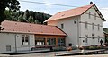
Mairie Gerbamont
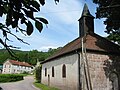
Saint-Del Chapel

crossroads


Economy and Infrastructure
In addition to a sawmill, Gerbamont is home to smaller craft businesses. In recent years the tourist offers in Gerbamont have been expanded. This is how many individual holiday homes were created. In the municipality of Gerbamont there are 19 farms (dairy farming, horse, cattle and poultry breeding, pig, sheep and goat farming). Some of the residents commute to the nearby industrial locations.
Transport links
Gerbamont is connected to its four neighboring communities by roads.
supporting documents
- ↑ toponym on cassini.ehess.fr
- ↑ Gerbamont on cassini.ehess.fr
- ↑ Gerbamont on insee.fr
- ↑ Farms on annuaire-mairie.fr (French)