Gerbépal
| Gerbépal | ||
|---|---|---|

|
|
|
| region | Grand Est | |
| Department | Vosges | |
| Arrondissement | Saint-Dié-des-Vosges | |
| Canton | Gerardmer | |
| Community association | Saint-Dié-des-Vosges | |
| Coordinates | 48 ° 9 ' N , 6 ° 55' E | |
| height | 583-1,083 m | |
| surface | 19.18 km 2 | |
| Residents | 589 (January 1, 2017) | |
| Population density | 31 inhabitants / km 2 | |
| Post Code | 88430 | |
| INSEE code | 88198 | |
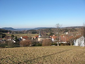
 View of Gerbépal from the west |
||
Gerbépal is a French commune in the Vosges department in the region of Grand Est (2015 Lorraine ). It belongs to the arrondissement of Saint-Dié-des-Vosges and to the municipal association of Saint-Dié-des-Vosges, founded in 2017 .
geography
The Vosges municipality Gerbépal, with 589 inhabitants (January 1, 2017), is located on the upper Neuné , a tributary of the Vologne , between the towns of Saint-Dié-des-Vosges and Gérardmer . The municipality extends from the Col du Plafond (620 m, transition to the Meurthe valley ) in the north to the Col de Martimpré (796 m, transition to the Vologne valley) in the south over a length of ten kilometers.
The districts of Aux Fourneaux, La Basse de Martimpré, Les Trexons and Martimpré belong to the 19.18 km² community .
Neighboring municipalities of Gerbépal are Anould in the north, Ban-sur-Meurthe-Clefcy in the east, Xonrupt-Longemer in the south, Gérardmer in the south-west, Arrentès-de-Corcieux in the west and Corcieux in the north-west.
history
In 1378 the village was first mentioned as Gerbepaltz . At that time it consisted of the hamlets of Ruxurieux and Vichibure and was part of the Martimprey lordship, which was assigned to the Bailliage of Bruyères .
A castle from 1532 was located near the chapel in the Martimpré district. It was destroyed in 1635 during the Thirty Years' War, the ruins torn down in 1830. Instead of the castle, two houses were built, one of which was burned down by German troops in 1944.
Population development
| year | 1962 | 1968 | 1975 | 1982 | 1990 | 1999 | 2007 | 2017 | |
|---|---|---|---|---|---|---|---|---|---|
| Residents | 431 | 449 | 380 | 436 | 483 | 503 | 530 | 589 | |
| Sources: Cassini and INSEE | |||||||||
Attractions
- Saint-Jean-Baptiste church, built in the late 17th century
- Sainte-Anne chapel in the Martimpré district, built in 1606
Economy and Infrastructure
There are 13 farms in the municipality (dairy farming, cattle breeding). In addition to tourism and small businesses (bakery, car repair, candle making), handicrafts and tourism are playing an increasingly important role. In the north of the municipality, in front of the Col du Plafond, there is a kart track .
The main road in the municipality connects Gerbépal with the city of Gérardmer and (via Anould ) with the sub-prefecture of Saint-Dié-des-Vosges as the D 8 . The D 86 leads from Gerbépal to the small town of Corcieux .
Personalities
Maurice Lemaire (1895–1979) comes from Gerbépal and held various ministerial posts in the French government between 1953 and 1957.
supporting documents
- ↑ vosges-archives.com/Gerbepal ( Memento of the original dated November 5, 2014 in the Internet Archive ) Info: The archive link was inserted automatically and has not yet been checked. Please check the original and archive link according to the instructions and then remove this notice. (French; PDF; 81 kB)
- ↑ Le château de Martimpré on gerbepal.free.fr (French)
- ↑ Gerbépal on cassini.ehess.fr
- ↑ Gerbépal on insee.fr
- ↑ Farms on annuaire-mairie.fr (French)
- ↑ gerbepal.free.fr/commerce local (French)


