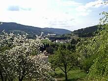
Cleurie (river)
| Cleurie | ||
| Data | ||
| Water code | FR : A4170300 | |
| location |
France
|
|
| River system | Rhine | |
| Drain over | Moselotte → Moselle → Rhine → North Sea | |
| source | in the municipality of Gérardmer in the Vosges Mountains, 48 ° 4 ′ 16 ″ N , 6 ° 49 ′ 8 ″ E |
|
| Source height | approx. 655 m | |
| muzzle | between Saint-Amé and Le Syndicat in the Moselotte Coordinates: 48 ° 1 ′ 16 ″ N , 6 ° 40 ′ 26 ″ E 48 ° 1 ′ 16 ″ N , 6 ° 40 ′ 26 ″ E |
|
| Mouth height | approx. 395 m | |
| Height difference | approx. 260 m | |
| Bottom slope | approx. 14 ‰ | |
| length | 19 km | |
| Catchment area | 77 km² | |
| Drain at the Cleurie gauge |
MQ |
2.4 m³ / s |
The Cleurie is a river in France that runs in the Vosges department in the Grand Est region .
geography
course
The source of the Cleurie is located in the Ballons des Vosges Regional Nature Park , west of Gérardmer , just 1,800 meters from the Lac de Gérardmer . The Cleurie initially flows west, reaches the northernmost point at Le Tholy and swings to the southwest. After passing the eponymous municipality of Cleurie , the river turns south and after a total of 19 kilometers flows into the Moselotte as a right tributary at the municipal boundary of Saint-Amé and Le Syndicat .
Tributaries
|
left tributaries
|
right tributaries
|
Places on the river
- Le Tholy
- La Forge
- Cleurie
- Bréhavillers, Le Syndicat parish
- Saint-Amé
Hydrology
At the Cleurie gauge - four kilometers from the estuary - a hydrological station has been measuring the flow of the river since 1967, which is given as an average of 2.4 m³ per second. Seasonally the discharge fluctuates between 2.8 to 3.5 m³ per second in the winter half-year and only 1 m³ per second in midsummer. The highest value was measured at 51.7 m³ per second during a flood on January 25, 1995. The average rainfall in the Cleurie catchment on the windward side of the Vosges is 1114 millimeters, well above the average for all of France.
Web links
- Débits caractéristiques de la Cleurie (French; PDF; 13 kB)
Remarks
- ↑ a b geoportail.fr (1: 16,000)
- ↑ a b c The information on the length of the river is based on the information on the Cleurie from SANDRE (French), accessed on January 22, 2012, rounded to the nearest kilometer.
- ↑ hydro.eaufrance.fr (station: A4173010 , option: Synthèse )


