Jeuxey
| Jeuxey | ||
|---|---|---|

|
|
|
| region | Grand Est | |
| Department | Vosges | |
| Arrondissement | Epinal | |
| Canton | Epinal-2 | |
| Community association | Epinal | |
| Coordinates | 48 ° 12 ′ N , 6 ° 29 ′ E | |
| height | 315-420 m | |
| surface | 8.49 km 2 | |
| Residents | 687 (January 1, 2017) | |
| Population density | 81 inhabitants / km 2 | |
| Post Code | 88000 | |
| INSEE code | 88253 | |
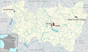
 Location of the commune of Jeuxey in the Vosges department |
||
Jeuxey (1793 still with the spelling Jenxey ) is a French commune with 687 inhabitants (as of January 1, 2017) in the Vosges department in the Grand Est region (until 2015 Lorraine ). It belongs to the Arrondissement Épinal and the municipal association Agglomération d'Épinal .
geography
The municipality of Jeuxey is located immediately northeast of the gates of Épinal , the capital ( prefecture ) of the Vosges department.
The approximately eight and a half square kilometers large municipal area of Jeuxey includes a section of the right Moselle tributary Saint-Ogon , the course of which turns north in Jeuxey when coming from the east, as well as the southern hinterland, which gradually rises to heights of over 400 meters. The highest point is 420 meters above sea level on a Vosges foothill in the southeastern tip of the municipality.
Around 200 hectares of the municipal area are forested, in the south the municipality has a share of the Forêt d'Épinal . The old village center is grouped around the church of Saint Guérin, the main settlement axis developed along the old road to Épinal. In addition to a few scattered farms in the south, there are newly developed residential areas north and west of the village center. The area around Jeuxey is used intensively for agriculture.
Neighboring communities of Jeuxey are Longchamp in the northeast, Deyvillers in the east, Épinal in the south and west and Dogneville in the northwest.
history
Cont
In the area of the municipality are the Fort des Adelphes and the Réduit de Voivre, two of the large fortifications built in a ring around Épinal after the Franco-German War .

The Fort des Adelphes , also called Fort Richepance , is 419 meters above sea level in a forest two kilometers south of the village center. The fortifications were intended to protect the road from Épinal to Saint-Dié . The fort, which was built between 1883 and 1885, was constantly expanded and expanded in the years up to 1913. The crew consisted of up to 235 men. The fortress, which is in relatively good condition, is used for military purposes and access is prohibited.
The Battery de la Voivre is located at 364 meters above sea level immediately west of Jeuxey in a forest on the border with the municipality of Dogneville. Since construction began in 1882, it was also part of the Festes Platz Épinal with a crew of no more than 100 and was primarily responsible for securing the road to Rambervillers . The fortification is in very poor condition and is owned by the municipality of Jeuxey. The bunker entrances were partially filled in order to create a motocross track on the site.
Population development
| year | 1962 | 1968 | 1975 | 1982 | 1990 | 1999 | 2007 | 2017 | |
| Residents | 508 | 550 | 596 | 657 | 699 | 688 | 661 | 687 | |
| Sources: Cassini and INSEE | |||||||||
Attractions
- Château de Failloux in the southwest of the municipality near Épinal, 18th century manor house with bell tower, park and orangery
- Saint-Guérin church with an organ by Théodore Jaquot from 1886
Economy and Infrastructure
In Jeuxey there are not only farms but also smaller trading and service companies. The largest employer in the municipality is the Carrefour hypermarket , which is halfway towards Épinal and has 250 employees.
The two-lane national road 57 ( E 23 ) runs through the west of the municipality of Jeuxey from Metz via Épinal to Besançon . The star-shaped main roads D 46 (from Rambervillers ), N 420 (from Saint-Dié-des-Vosges ) and D 11 (from Gérardmer ) meet the N 57 in the municipality of Jeuxey According to plans, the Carrefour supermarket will also be connected to the northern periphery of Épinal by a new route.
supporting documents
- ↑ toponym on cassini.ehess.fr
- ↑ Le fort des Adelphes on fortiffsere.fr (French)
- ↑ La batterie de la Voivre on fortiffsere.fr (French)
- ↑ Jeuxey on cassini.ehess.fr
- ↑ Jeuxey on insee.fr
- ↑ lechateaudefailloux.com (French)
- ↑ tresordesregions.mgm.fr (French)
- ↑ blueprint photo


