
Canton of Monthureux-sur-Saône
| Former canton of Monthureux-sur-Saône |
|
|---|---|
| region | Lorraine |
| Department | Vosges |
| Arrondissement | Neufchâteau |
| main place | Monthureux-sur-Saône |
| Dissolution date | March 29, 2015 |
| Residents | 2,447 (Jan 1, 2012) |
| Population density | 18 inhabitants / km² |
| surface | 139.21 km² |
| Communities | 11 |
| INSEE code | 8817 |
The canton of Monthureux-sur-Saône was until 2015 a French constituency in the Arrondissement Neufchâteau in the Département Vosges and in the Lorraine region ; its main town was Monthureux-sur-Saône .
location
The canton was in the southwest of the Vosges department.

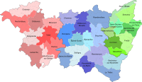
Location of the canton of Monthureux-sur-Saône within the Arrondissement of Neufchâteau
Location of the canton of Monthureux-sur-Saône within the Vosges department


Communities
The canton consisted of eleven municipalities:
| local community | Population year | Area km² | Population density | Code INSEE | Post Code |
|---|---|---|---|---|---|
| Ameuvelle | 56 (2013) | 5.56 | 10 inhabitants / km² | 88007 | 88410 |
| Bleurville | 353 (2013) | 20.25 | 17 inhabitants / km² | 88061 | 88410 |
| Claudon | 218 (2013) | 21.72 | 10 inhabitants / km² | 88105 | 88410 |
| Fignevelle | 52 (2013) | 4.4 | 12 inhabitants / km² | 88171 | 88410 |
| Gigneville | 77 (2013) | 5.58 | 14 inhabitants / km² | 88199 | 88320 |
| Godoncourt | 139 (2013) | 11.38 | 12 inhabitants / km² | 88208 | 88410 |
| Martinvelle | 120 (2013) | 24.73 | 5 inhabitants / km² | 88291 | 88410 |
| Monthureux-sur-Saône | 878 (2013) | 19.02 | 46 inhabitants / km² | 88310 | 88410 |
| Nonville | 213 (2013) | 8.91 | 24 inhabitants / km² | 88330 | 88260 |
| Regnévelle | 130 (2013) | 8.62 | 15 inhabitants / km² | 88377 | 88410 |
| Viviers-le-Gras | 180 (2013) | 9.04 | 20 inhabitants / km² | 88517 | 88260 |
Population development
| 1962 | 1968 | 1975 | 1982 | 1990 | 1999 | 2006 | 2012 |
|---|---|---|---|---|---|---|---|
| 3,322 | 3,295 | 3,074 | 2,948 | 2,764 | 2,614 | 2,442 | 2,447 |